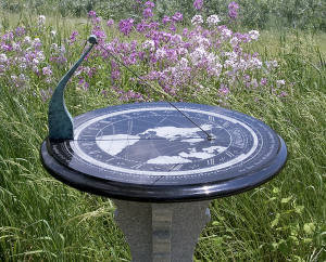
The Longitude Dial is a precision timepiece with no moving parts. It relies on the motions of the Earth — daily rotation on its axis and annual revolution around the Sun — to tell the time to the nearest minute. It is designed for the exact latitude and longitude of the location you choose. That point on Earth will be in the center of the dial.
Detail of the center point of the map, marked with a small circle. This is the point from which the map and hour scale are projected on to the dial plate.
The Longitude Dial is based on an idea published in Nuremberg, Germany, in 1607 by Franz Ritter (died 1641). In his quest to promote the “noble art of making sundials”, Ritter devised a world map projected from Nuremberg with its lines of longitude arrayed to serve as hour lines. Perhaps due to its complexity, however, it was never properly developed as a form of sundial – until now.
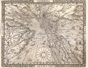
Franz Ritter’s gnomonic projection world map, made for Nuremberg, Germany. Ritter published his first version of this map in 1607 in a small book on sundials titled Speculum Solis (“Mirror of the Sun”). The 1610 edition of this work contains a larger, refined, and more detailed engraving. The same printing plate, slightly modified was used for this 1640 impression of Ritter’s map. (Courtesy of Donald Heald)
Ritter’s “central” or “gnomonic” map projection was adopted in the 1800s as a navigational aid for studying direct sea routes. One of the unique features of this projection is that a straight line drawn between any two points on the map represents the shortest distance between them, illustrating the great circle routes followed by today’s airlines.
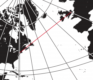
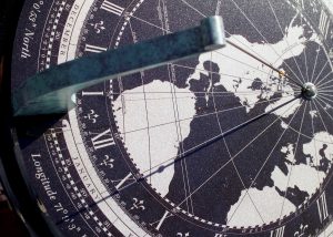
Detail of Longitude Dial, No. 18 (Garden style), made for a residence in Poughkeepsie, New York. As indicated by the straight red line, the most direct (great circle) route from this point to London is over Newfoundland.
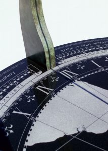
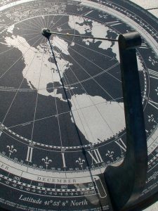
The Longitude Dial tracks the Earth’s daily rotation on its axis (360° in 24 hours or one degree every four minutes) and its annual orbit around the Sun. The wire, which runs from the North Pole on the map to the top of the post, is called the gnomon, after a Greek word meaning “one who knows”, because its shadow indicates the time and other information on the map. The gnomon points to the celestial pole, close to Polaris, the North Star.
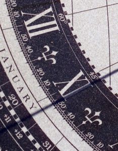
Because the Earth is tilted on its axis and has an elliptical orbit around the Sun, solar time (the time shown on a sundial) differs from standard (GPS) time by varying amounts during the course of the year. This difference is called the equation of time. The number of minutes that need to be added or subtracted to convert solar time to standard time is shown on the calendar circle adjacent to the date. No adjustment is needed when the variance is shown “0” (on or about April 15, June 12, September 1, and December 25, when solar time and standard time are the same).
To find standard (GPS) time to the nearest minute, look at the solar time shown by the gnomon’s shadow. In this photograph, the gnomon’s shadow indicates the solar time on the hour scale is 10:54 a.m. On the adjacent calendar scale, find the equation of time for todays’ date: if the date is December 20, which shows “-3”, subtract 3 minutes, so standard time would be 10:51 a.m.; if January 15, add 9 minutes, so standard time would be 11:05 a.m.
Wherever the gnomon’s shadow falls on the map shows where it is noon in the world, and wherever it crosses the degree scale tells you it’s longitude. In this image, it is noon everywhere 43° West of the Prime Meridian at Greenwich, England. If you look carefully, you will be able to observe the Earth’s rotation in the movement of the gnomon’s shadow.
Before the advent of railroads, each town operated according to its local time regulated by the Sun: its time therefore was different from any place to the East or to the West. Because the Earth revolves on its axis once every 24 hours, which is 15° every hour or 1° every four minutes, local noon in Boston (about 71° West) will occur 12 minutes earlier than local noon in New York (about 74° West). Time zones, introduced to regulate railway timetables, gave each town within the same zone the same standard time. In 1884, when the Royal Observatory at Greenwich, England, became the prime meridian of the world, time zones provided the framework for an international timekeeping system.
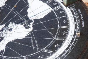
The dotted line on the dial plate shows its meridian (the dial’s longitude), which the gnomon’s shadow is about to cross to indicate local noon. Since the dial’s longitude is just over 71° West of the prime meridian at Greenwich, it will take just under 16 minutes to reach XII which lies on the 75° meridian, the line on which Eastern Standard Time zone is measured, five hours later than Greenwich Mean Time.
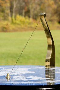
The gold bead on the gnomon marks the point from which the map and hour scale are projected. The bead’s shadow indicates the place on the map where the Sun is directly overhead. On the summer solstice, its shadow will follow the line labeled “Tropic of Cancer” and at the equinoxes, it will trace the straight line of the Equator. This photograph was taken on September 19, about three days before the Autumnal Equinox, when the Sun crosses the Equator on its apparent journey South.
In addition to the Equator and the Tropics, other lines may be engraved on the dial plate to mark the date of a special occasion, such as a marriage, an anniversary, or the birth of a child. On the appointed day, the bead’s shadow will commemorate the event by following its line throughout the day.
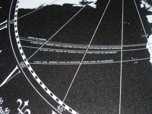

Made in 2011 to commemorate the 400th anniversary of Hatfield House in England, this dial (Longitude Dial, No. 19) is engraved with lines marking three special occasions in the history of Lord Salisbury’s family: May 4, 1605, when Robert Cecil, the first minister to King James I, was created the first Earl of Salisbury; June 8, 1607, when he acquired the Royal estate of Hatfield on which he built Hatfield House; and May 24, 1612, the day he died. The bead’s shadow traces each line on its appointed date.
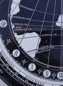
The client who commissioned this dial for his home in São Paulo, Brazil, wanted to honor each member of his family with their names and birth dates. In this way, his dial could capture this moment in the life of his family in a meaningful way for both present and future generations. On each birthday, the bead’s shadow will follow the line on its appointed date.
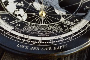
One of the most captivating things about sundials are their inscriptions, which range from a personal dedication to a short poem. The Longitude Dial has been designed to accommodate inscriptions of different lengths. The client who commissioned Longitude Dial No. 18 is particularly fond of 17th century English poetry and selected a passage from the last verse of “The Garden”, a poem by Andrew Marvell published in 1681.
Since Daylight Saving Time (known as British Summer Time in the United Kingdom) occupies almost two-thirds of the year in areas where it has been adopted, it is usually selected for the Longitude Dial. Nevertheless, depending on where you live and your personal preference, you have the choice of either Daylight Saving or Standard Time. Just remember to add or subtract an hour at the appropriate time of year.
Longitude Dial, No. 8, Pomfret School, Connecticut.
Standard time was chosen for this dial, because it occupies most of the academic year at the school. Therefore, during the summer when the school is in recess, an hour has to be added to tell the correct time.
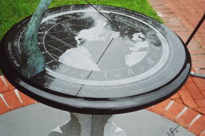
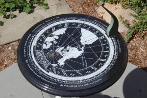
Because the gnomon points due North, the dial serves as a direction-finding, as well as a time-finding instrument. The polished gabbro dial plate is a form of a nephoscope, a cloud-observing instrument used in the 1800s to determine the direction of the wind by the drift of clouds reflected in its black mirrored surface. The Longitude Dial works in the same way, revealing the wind’s direction by the movement of clouds reflected in its surface.
William Andrewes was born and educated in England. He trained as a clockmaker, working under the guidance of George Daniels, Martin Burgess, and others, and as a designer, graduating from Kingston College of Art in 1972.
Specializing in the field of time measurement for over four decades, he has worked at Eton College (1973-1977), the Old Royal Observatory, Greenwich (1974-1977), The Time Museum (1977-1987), and Harvard University, where he was the David P. Wheatland Curator of the Collection of Historical Scientific Instruments (1987-1999). He organized the Longitude Symposium (1993), edited The Quest for Longitude (1996), and was co-author with Dava Sobel of The Illustrated Longitude (1998). For his contributions to horology, the Worshipful Company of Clockmakers awarded him the Harrison Gold Medal in 2007.
William Andrewes has been awarded three patents for the Longitude Dial. Examples have been made for clients in Brazil, England, France, Mexico, Spain, and the United States.
For the development of the Longitude Dial, William Andrewes enlisted the help of some highly talented specialists. The initial stage of resolving the mathematical problems of the map and the hour scale involved Daniel Strebe. Gary Hahn and Damon Meibers have been very close allies in every project. Some of the others who have assisted in the making are included in the images of the dials on which they worked. To all who have helped, William Andrewes expresses sincere thanks for their extraordinary dedication and skill.
My interest in sundials began about 1976 when I met Roderick and Marjorie Webster, the Curators of the wonderful collection of astronomical instruments in the Adler Planetarium, Chicago. The Websters inspired and encouraged me, showing extraordinary hospitality and generously sharing their expertise and resources from their collection and library. In January 1979, they invited me to a meeting of the Chicago Map Society and introduced me to David Woodward (1941-2004), the famous English historian of cartography who was, at that time, Curator of Maps at the Newberry Library. On hearing that I was Curator of The Time Museum, David offered to show me the example of Ritter’s map that he had recently acquired for the Newberry Library. As soon as I saw it, I was captivated by the idea that such a map existed and resolved to make one for my own location. With the responsibilities of my new job at The Time Museum however, I did not have time to develop it beyond a rather primitive paper model. Nevertheless, the seed of the idea was planted.
A quarter of a century went by before it could grow. I left Harvard at the end of 1999 and worked as a museum consultant, but, after 9/11 while I was working on an exhibition at the Frick Collection, the museum world changed, and I realized that I would no longer be able to support my family with just one line of work. Developing Ritter’s map projection seemed like an interesting project that would be worth pursuing and might bear fruit. That it had never been done before in any formal way should have been a clue as to how hard the task would be. During the fifteen months that it took before the first prototype was ready, I made many enduring friendships with specialists in the arts, crafts, and sciences who helped me through the challenges of the design and construction of the first prototype, which was completed in October 2003.
I call this work “The Longitude Dial” for two reasons: first, its hour lines are the lines of longitude on its map; second, the first prototype was finished at the end of October 2003, a few days before the tenth anniversary of “The Longitude Symposium.” From this event came Dava Sobel’s best-selling book Longitude, which gave John Harrison, who has so strongly influenced my work, the international recognition he so richly deserved.