The Longitude Dial is available in three models to suit a variety of settings, from house to apartment to campus or corporate headquarters. Each dial is engraved with the desired inscription and special occasions, marked with a unique serial number, and supplied with a signed and dated certificate of origin.
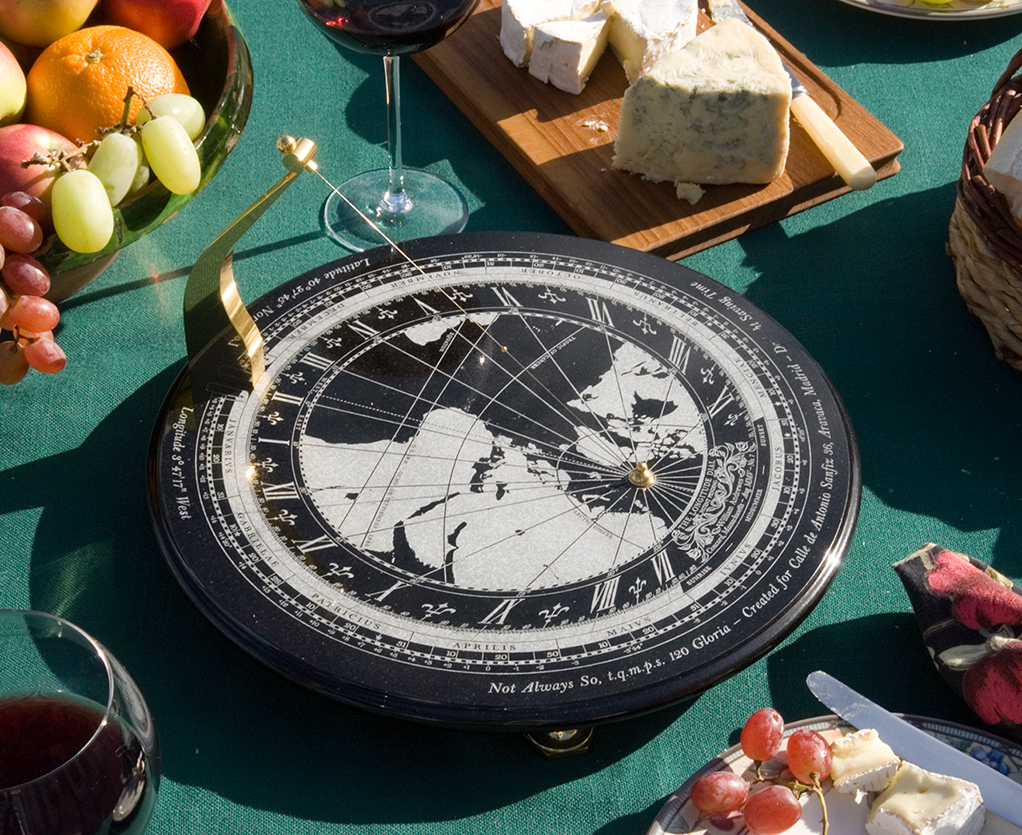 Aravaca, Madrid, Spain
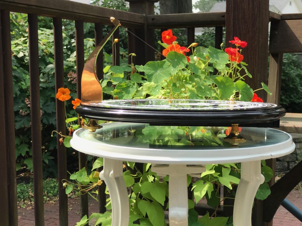 Santa Barbara, California
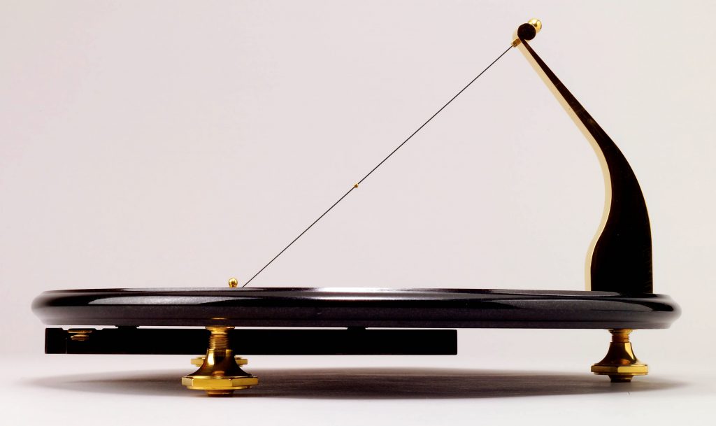 Pauling, NY
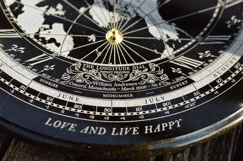 New York, NY
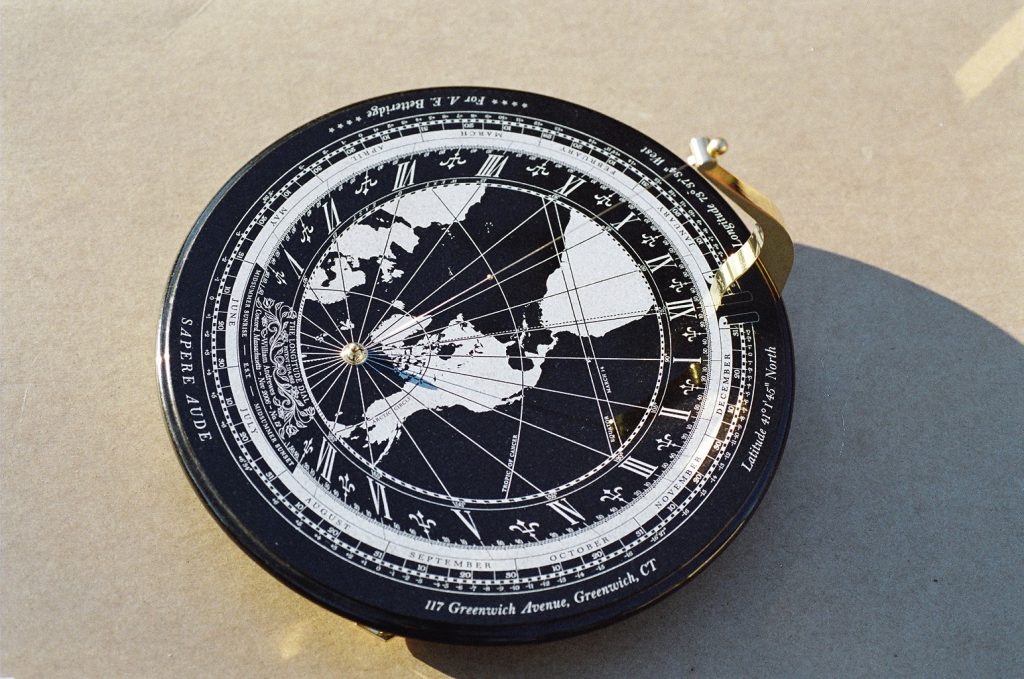 Greenwich, CT
 Pauling, NY
 Key Biscayne, Florida and São Paulo, Brazil, two sides of the same dial.
The Longitude Dial rediscovers time as a measure of the rhythm of nature and expresses it by balancing art and science. In doing so, it has an eternal heart of its own, one that belongs to our family.
Fernando Barnuevo Sebastian de Erice and Gloria Ybarra Malo de Molina
Owners of Longitude Dial No. 7 (Terrace style)
Measuring about 12 inches (30 cm.) in diameter, the Terrace model can be used in a sunny indoor area, such as an atrium, and easily moved to a sun porch or garden terrace of the same house. With the aid of its bubble level, the Dial’s three screw feet can be easily adjusted to accommodate different surfaces. Because it can be personalized in many specials ways, it is a unique gift for an anniversary, the birth of a child, a wedding, or just to remind someone that you love them.
 "For everything there is a season, and a time for every matter under heaven (Ecclesiastes 3, ESV Bible)
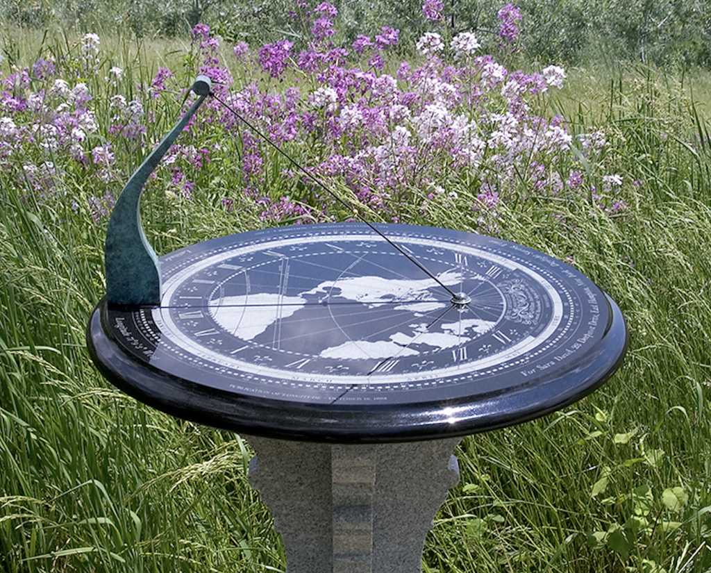
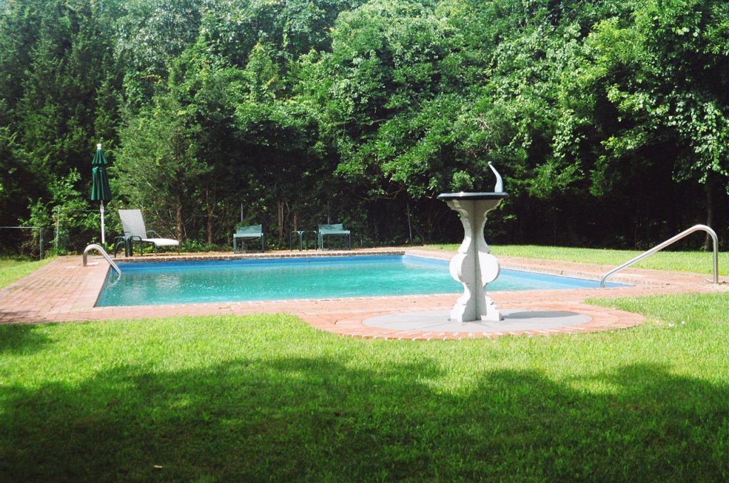 East Hampton, Long Island: Time to relax
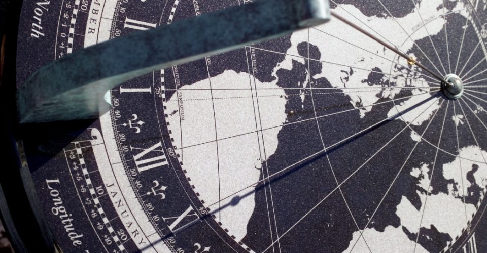 When the local solar time is 10:54 AM (shown here), the shadow on the degree scale indicates it is noon everywhere 43° west of Greenwich
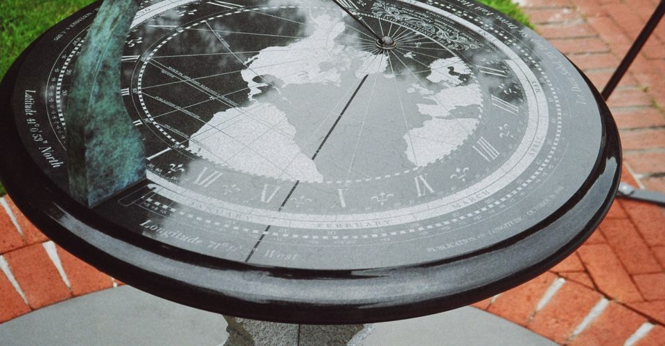 Clouds reflected in the polished surface of the dial indicate by the direction they are moving which way the wind is blowing
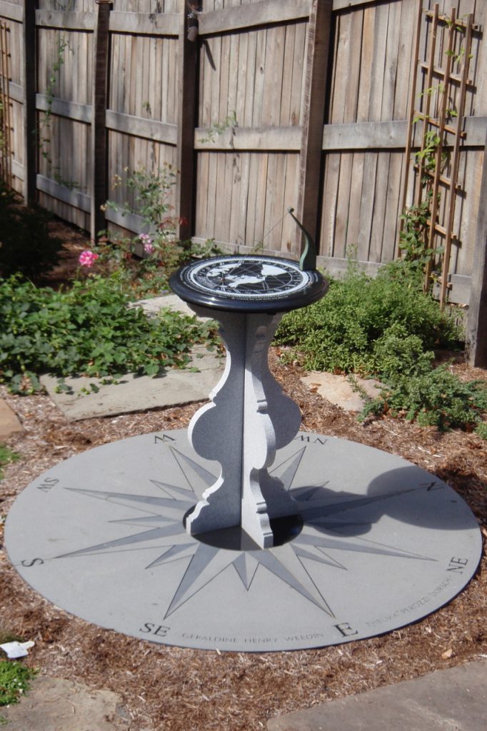 Poughkeepsie, New York: the theme of this garden dial is an industrious bee
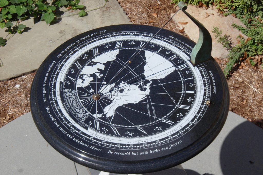 The inscription, from Andrew Marvel’s 1681 poem "The Garden”, begins: "And, as it works, th’ industrious bee, Computes its time as well as we."
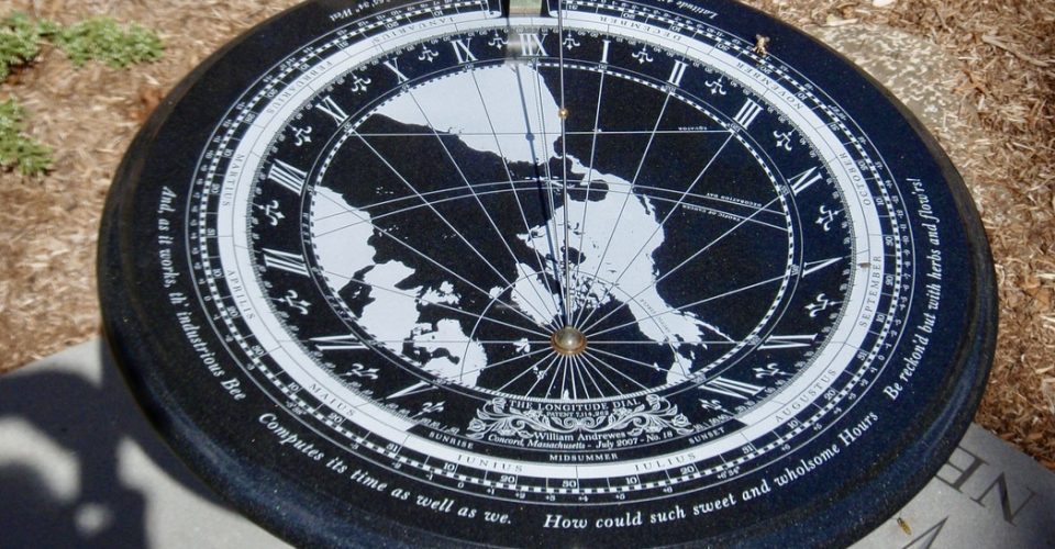 And continues: "How could such sweet and wholesome hours, Be reckoned but with herbs and flowers!”
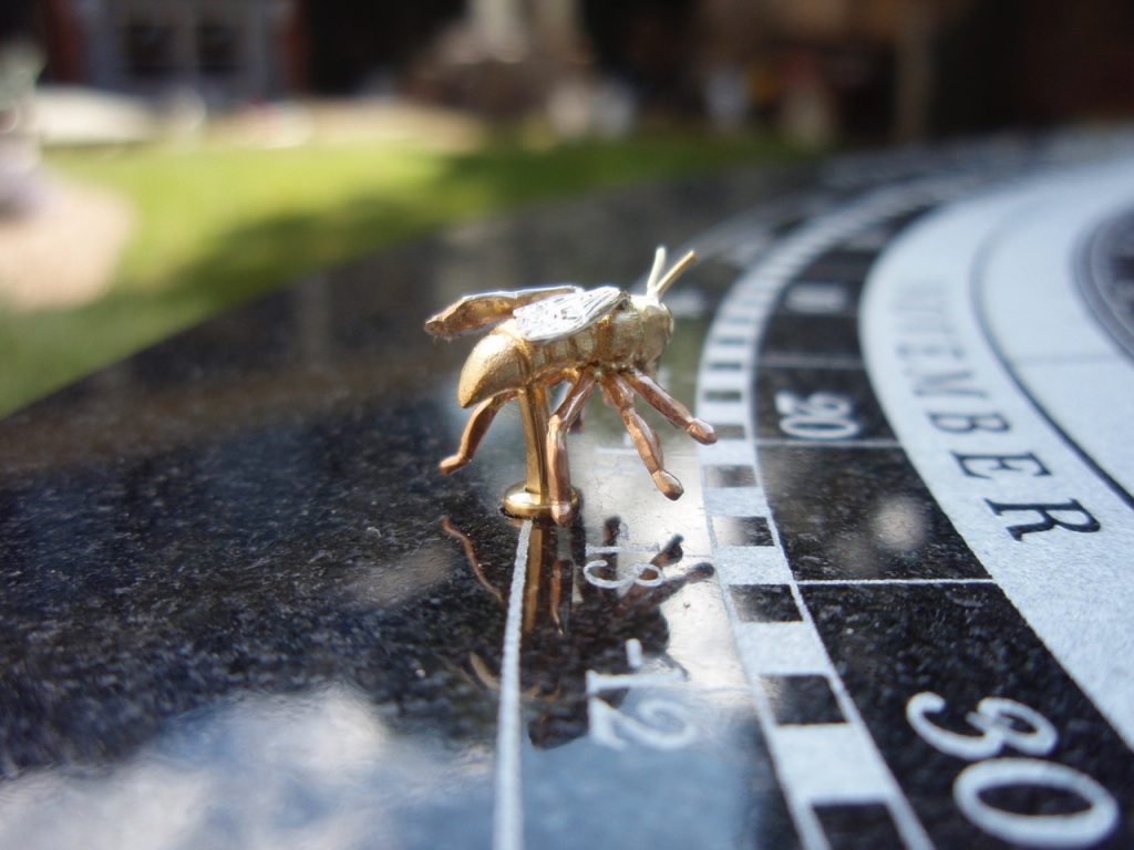 The bee, made of red, white, and yellow gold, has alighted on November 22, a date of special significance to the owner of this dial
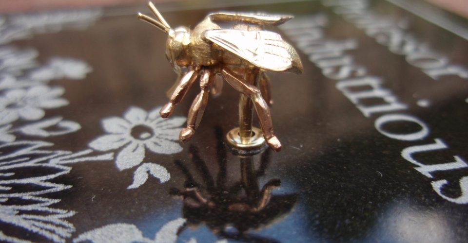 The industrious bee has a special place inside the house to stay safe and warm during the winter
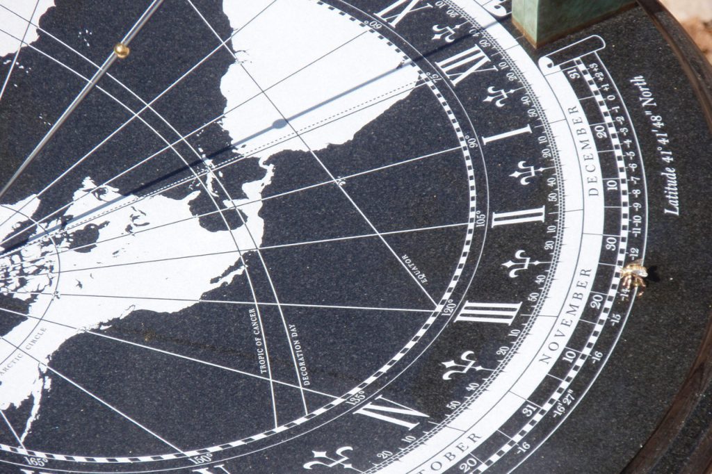 The shadow of the gnomon's gold-plated bead showing the Sun's path just North of the Equator on September 19
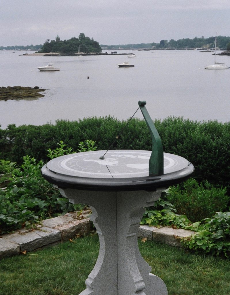 Overlooking the harbor in Greenwich, Connecticut: time to reflect upon life — what you have done, where you are, and who you would like to be
I look at my wristwatch a hundred times a day without thinking, then immediately forget what time it is. But when I go out to consult my Longitude Dial, observe the shadow of the gnomon, and adjust for the equation of time, I feel a delightful sense of accomplishment and enrichment. Time has become more meaningful to me for the experience of telling it in this beautiful way.
Dava Sobel, author of Longitude, Galileo’s Daughter, The Planets, and The Glass Universe
Owner of Longitude Dial No. 4 (Garden style)
For hundreds of years, sundials have been used to complement the elegance and beauty of a garden, silently recording the passage of time and the natural cycles on which life on Earth depends. Sometimes, they include a verse from a poem or other literary quote meaningful to the owner. The Garden-style Longitude Dial is about 23 inches (58 cm.) in diameter and is mounted on a pedestal secured on a firm foundation. A compass rose can also be provided with features, such as the direction and distance of significant places in the life of the client.
The Garden Dial requires at least two site visits, the first is to discuss with the client the desired features and other details, choose an appropriate location that will gives an optimal amount of sunshine throughout the year, and resolve the foundation requirements with a local builder to the specifications provided; on the second visit, after the foundation and the dial parts are ready, the pedestal and the dial will be precisely leveled, oriented, and secured in place.
ranges in size according to the design details of the commission. The smallest so far has been about 3.3 feet (1 meter) in diameter, and the largest about 16.4 feet (5 meters). Like the Garden Dial, it is installed on a custom pedestal in a location that promises abundant sunshine and can be designed to provide calendrical information obtained from the Sun’s apparent motion. The compass rose that surrounds these dials provides a unique opportunity to introduce other information of general interest, such as the direction and distance of cities throughout the world.
The Longitude Dial allows students to observe the effects of Earth’s rotation, revolution, and axis tilt firsthand. It is an excellent teaching tool — a fascinating synthesis of ancient wisdom and modern ingenuity.
Joshua Lake, Science Department Chair, Pomfret School, Connecticut
Longitude Dial No. 8 (Monumental style)
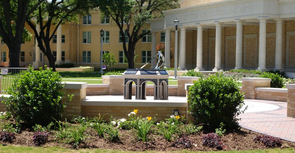 The TCU Dial looking Southwest toward the Walsh Center for Performing Arts
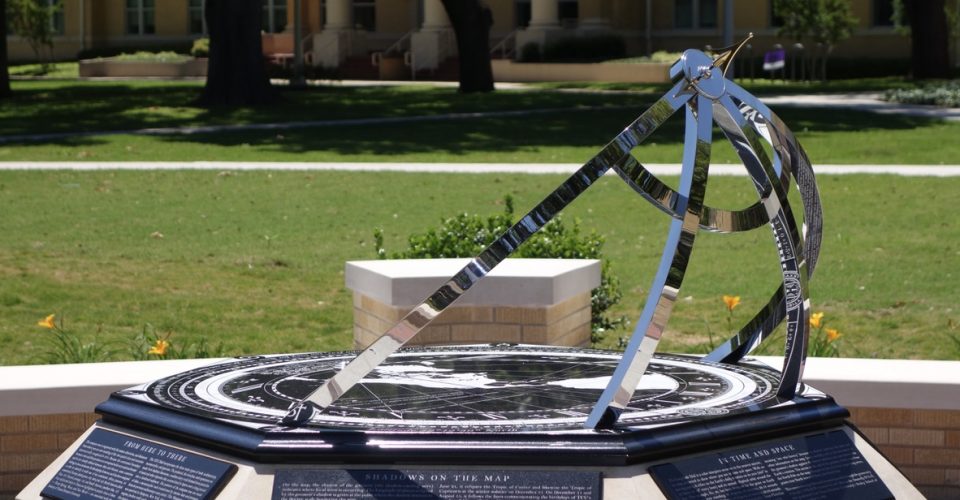 The design of the polished stainless steel arms is based on an armillary sphere, an instrument used for teaching astronomy during the Renaissance
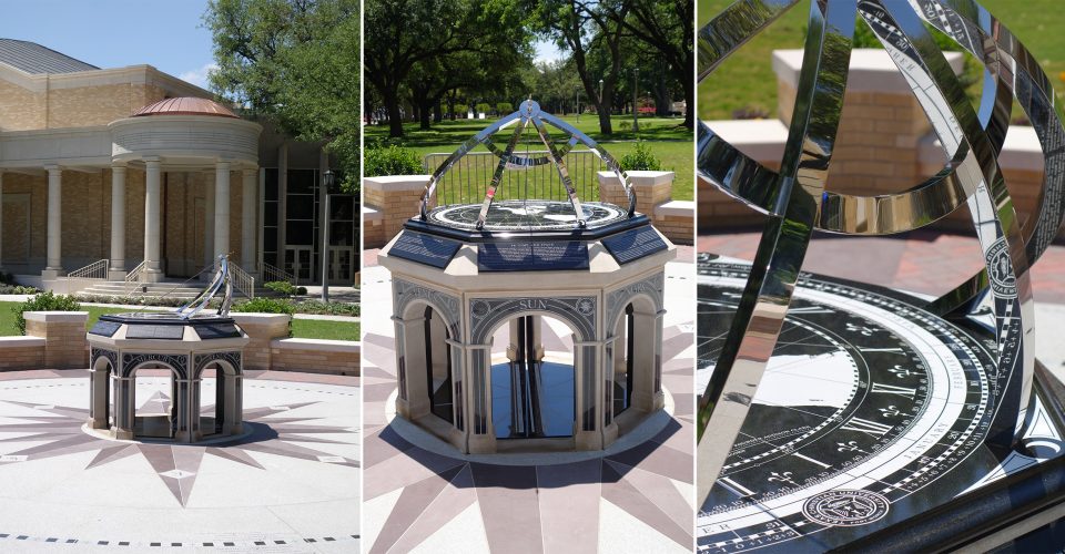 Each side of the pedestal’s heptagonal design represents one of the seven "wandering stars” after which, long ago, the days of the week were named
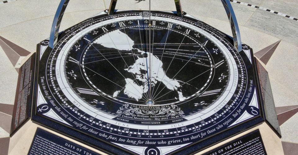 The inscription around the perimeter comes from a poem called “Time is”, written in 1904 by Henry van Dyke (1852-1933)
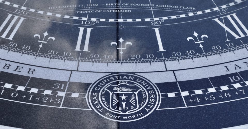 Texas Christian University was founded as AddRan College in 1873 and moved to its present location in Fort Worth in 1910
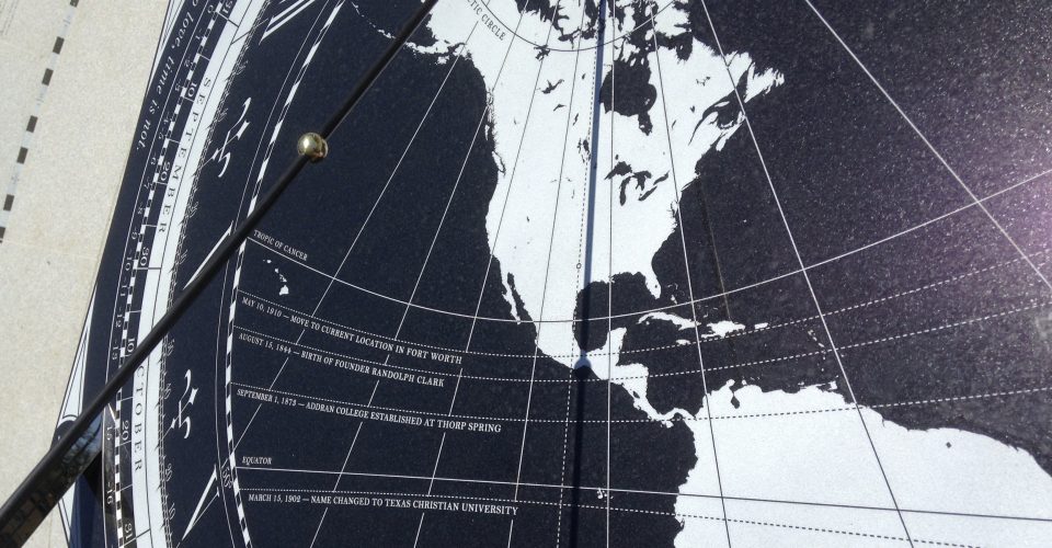 To commemorate important events in TCU's history, the gnomon bead’s shadow will follow each special occasion line on its specified date
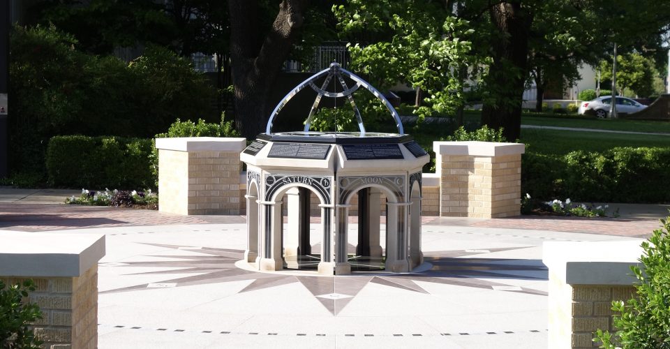 Looking from the South at the narrow slot through which the Sun will shine at noon on the meridian
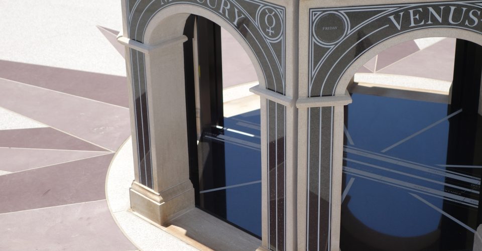 When the Sun is due South, its light shines through the pedestal on to the meridian line under the dial
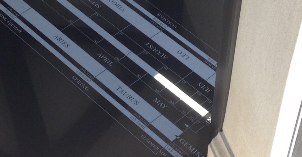 The length of its beam indicates the date, the sign of the zodiac, the hours and minutes of daylight and darkness, and the season
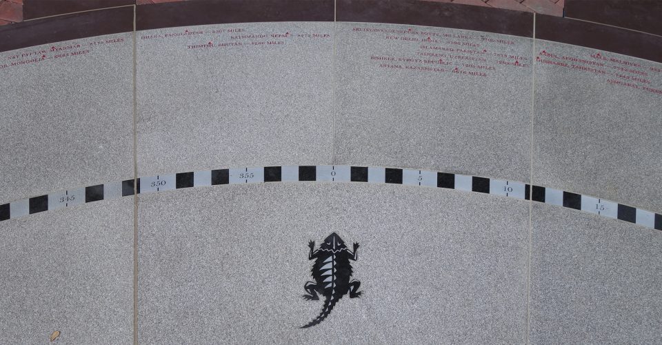 On the compass rose, TCU’s mascot, the horned frog, points in the direction of due North
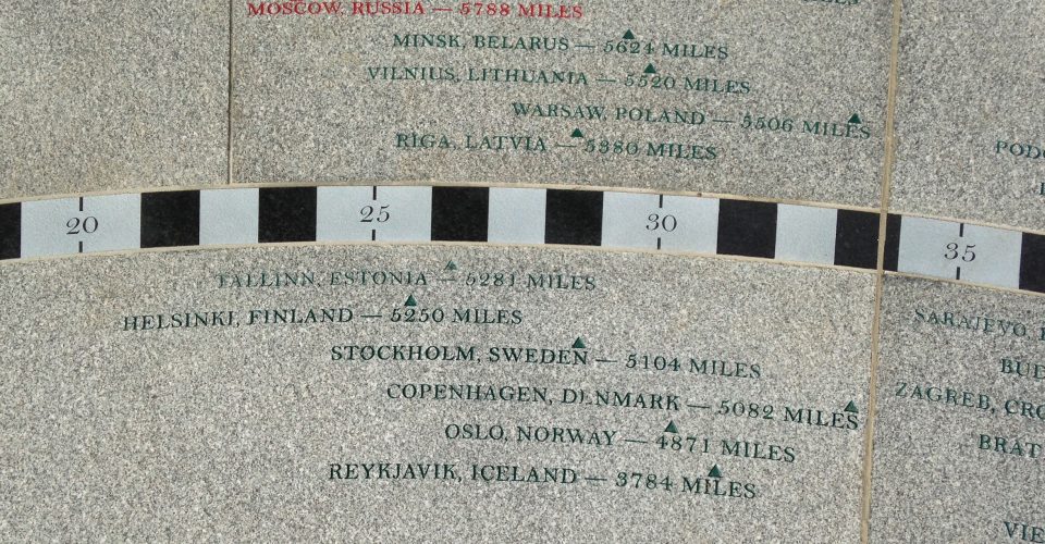 The compass rose bears the names, directions, and distances of 196 capital cities, each marked in a color to identify the continent to which it belongs
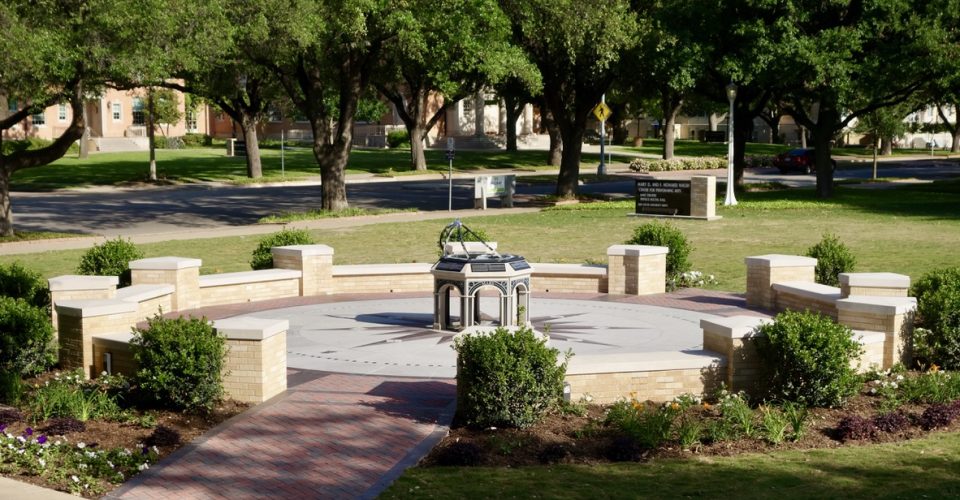 General view looking Southeast toward South University Drive
ORIGINS: The commissioning of this work by the Texas Christian University was made possible through the generosity of Joseph I. O’Neill III, to honor his wife Marion Jan Donnelly O’Neill, who graduated from Texas Christian University’s Neeley School of Business on June 4, 1969. The TCU Dial is situated at 32º, 42′, 39.14” North, 97º, 21′, 38.79” West, close by the F. Howard and Mary D. Walsh Center for Performing Arts on South University Drive. TCU is marked in the center of the map with a gold pin. The inscription around the perimeter of the dial is from “Time is”, a poem composed in 1904 by Henry van Dyke (1852 – 1933) for a sundial in Katrina Trask’s Yaddo Gardens in Saratoga Springs, New York: “Time is too slow for those who wait, too swift for those who fear, too long for those who grieve, too short for those who rejoice, but for those who love, time is not.”
COMMEMORATING SPECIAL OCCASIONS: On December 11th and August 15th, the gnomon bead’s shadow follows the lines commemorating the birthdays of TCU’s founders Addison Clark and Randolph Clark, and, on September 1st, their founding of AddRan College at Thorp Spring in 1873. On March 15th each year, it tracks the path of the Sun on the day in 1902 that the name AddRan College was changed to Texas Christian University and, on May 10th, TCU’s move in 1910 to its present location in Fort Worth.
DESIGN: The gold-plated bead on the gnomon (the shadow-casting rod) marks the center point of the map projection and the four polished stainless steel arms that support the gnomon: in the ancient geocentric concept of the heavens, this bead would represent the Earth at the center of the universe while the arms portray great circles of a celestial sphere. The concept of this design is based on an armillary sphere, an instrument employed during the Renaissance for teaching astronomy.
The dial’s pedestal is a heptagon, each side representing one of the seven planets from which the names of the seven days of the week evolved. In their concept of an Earth-centered universe, the ancient Egyptians believed that the Sun and Moon were like the other five “wandering stars” visible with the naked eye and listed them according to the speed of their apparent motion, beginning with the slowest: Saturn, Jupiter, Mars, Sun, Venus, Mercury, and Moon. Each hour was assigned to a planet and the day was named for the one that presided over its first hour. Therefore, starting with Saturn for the first hour (Saturn’s day) and repeating this same order throughout a 24-hour period (12 of daylight and 12 of darkness), the first hour of the next day would belong to the Sun, hence Sunday. The names by which ancient civilizations called these wandering stars evolved through contributing cultures and traditions into the names of the seven days of the week we use today.
Each of the seven arches is named for one of these wandering stars. In the upper right corner of each arch is the planetary symbol. In the upper left corner is the name of that day in seven different languages, some with Greco-Roman origins and others, such as English, with Germanic roots. After their flight from Egypt, the Jews made Saturn’s day the last day of their week, their Sabbath. Sunday remained the first day of the week in the early Christian church, but is now considered in the majority of countries as the last day, part of the weekend.
The compass rose is engraved with the names, directions, and distances of 196 capital cities. Because the continental boundary between Asia and Europe does not correspond with every national border and is not clearly defined between Asia and Oceania, some countries belong in two continents. In this instance, however, each has been assigned a color to identify it with one of six continents: Africa (maroon, 54 countries), Europe (green, 48), Asia (red, 45), North America (dark blue, 23), Oceania (rust red, 14), and South America (light blue, 12). Four additional cities in Texas are highlighted in purple: three of these — Thorp Spring (near Granbury), Waco, and Fort Worth — are associated with the history of TCU.
MATERIALS: The TCU Dial incorporates the three main types of rock: sedimentary, metamorphic, and igneous. The pedestal, the benches, and capstones are made from Indiana limestone, a sedimentary rock formed from particles of sand and other deposits that accumulated in layers over a long period into a hardened sediment. The pointers of the compass rose are made of slate, a metamorphic rock transformed by intense heat and pressure from its previous sedimentary state (shale). This “Hampton purple” slate was quarried in Granville, New York. Igneous rocks are formed when magma (molten rock) cools and hardens. Two types have been used in this design: a grey granite from Barre, Vermont, for the compass rose pavers, and a micro-fine gabbro from India for the dial plate, the meridian plate, and other engraved parts.
Texas Christian University
2800 South University Drive, Fort Worth, Texas,76109
Telephone: (001) 817-257-7000
Website: https://www.tcu.edu
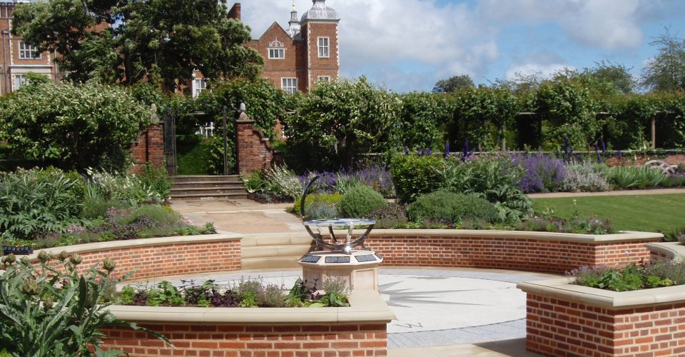 Located in the West Wing Garden, the Hatfield Dial was commissioned to celebrate the 400th anniversary of Hatfield House
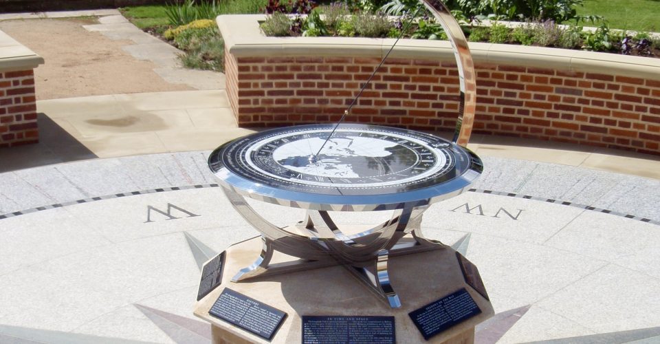 The design of the frame is based on an armillary sphere, an astronomical instrument used for teaching at the time Hatfield House was built
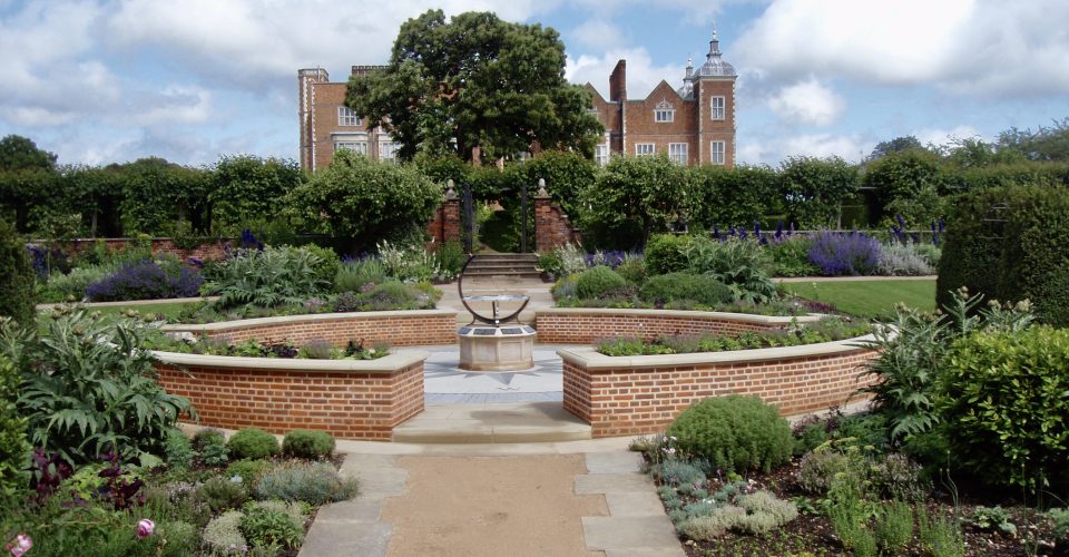 View from the West
 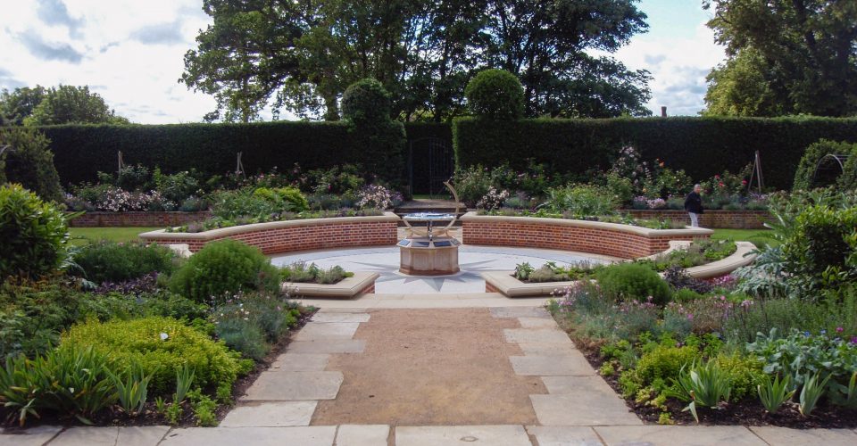 View from the East
 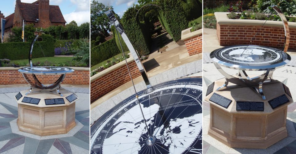 On the left in the background is the Old Palace at Hatfield, where Henry VIII’s daughter Elizabeth lived before she became Queen in 1558
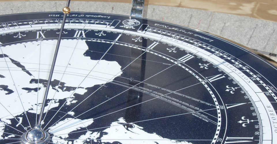 The gnomon's shadow indicates noon on the map and local time on hour scale. The bead's shadow shows where the sun is overhead
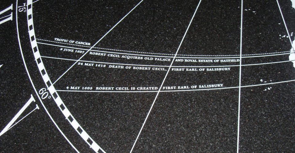 Three special occasion lines engraved on the dial commemorate the life of Robert Cecil, the first Earl of Salisbury (1563-1612)
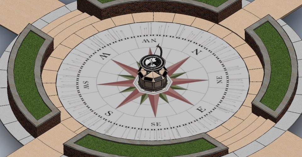 Detail of the overall design of the Hatfield Dial and its compass rose
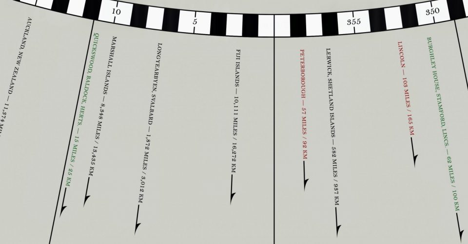 Compass rose detail showing the direction and distance of 125 places. Those in green have historical associations with the Cecil family
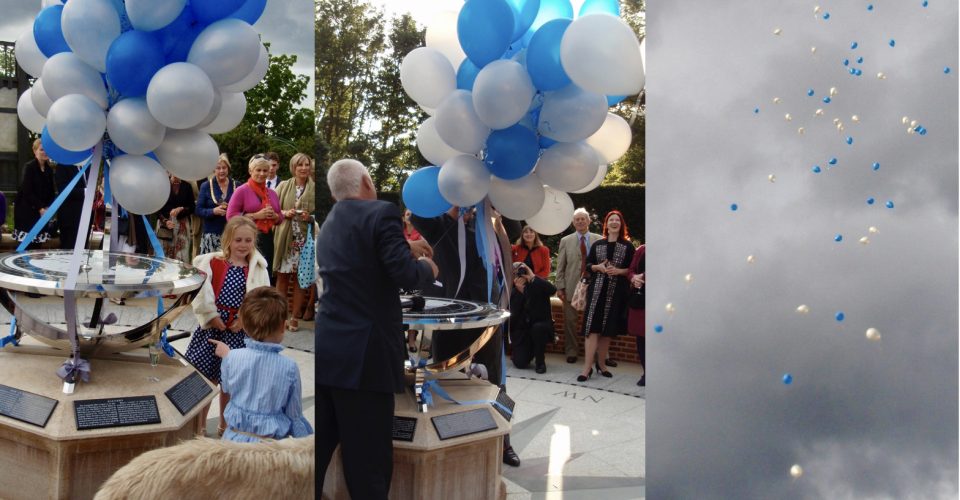 The grand opening of the Hatfield Dial, celebrating the 400th anniversary of Hatfield House, took place on Thursday, 23rd June, 2011
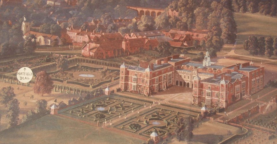 Birdseye view of Hatfield House and Gardens marked with the location of the Hatfield Dial (painting by Marcus May)
ORIGINS: The Hatfield Dial was commissioned by Robert, Seventh Marquess of Salisbury, and his family to mark the 400th anniversary of Hatfield House in 2011 and to commemorate the life of Robert Cecil (1563-1612), chief minister of King James I and First Earl of Salisbury, for whom the house was built. The dial is located in the Sundial Garden at latitude 51º:45′:38.19” North of the Equator and longitude 0º: 12′ : 40.56” West of Greenwich, about 75 yards southeast of the Old Palace where Henry VIII’s daughter Elizabeth was residing before she became Queen in 1558. Hatfield House lies in the center of the map. Engraved on the dial plate is a passage from an ode by Ben Jonson (1572 – 1637), a playwright and poet sometimes employed by Robert Cecil: “In small proportions, we just beautie see: And in short measures, life may perfect bee.”
DESIGN: The design of the polished stainless steel arms supporting the dial plate is based on an armillary sphere, a scientific instrument depicting the heavens that was widely used for teaching astronomy at the time Hatfield House was built. In addition to telling the time, the dial plate serves as a form of nephoscope, a cloud-observing instrument used in the 1800s to observe the direction of the wind by the drift of clouds reflected in its polished black surface.
The dial plate, information panels, and degree scale are made from a micro-fine igneous rock called gabbro, quarried in China and India. The pedestal is carved from Clipsham limestone, a sedimentary rock found in Lincolnshire not far from Burghley House, where Robert Cecil’s father, Lord Burghley, lived. The compass rose is composed of Cornish granite pavers with large pointers of green Cumbrian slate and small pointers of blue and red Welsh slate. Outside the gabbro degree scale, which is divided from 0º to 360º in a clockwise direction, are arrows showing the direction and distance of 125 places throughout the world: those marked in red point to English cathedrals that were prominent at the time Hatfield House was built; those in black refer to well-known cities and islands; and those in green have historical associations with the Cecil family.
From an aerial view, you will notice that the compass rose is angled about 3º from the pathways leading to the dial, which are aligned with the house and its surrounding landscape. The Old Palace, built about 1485, also has its own independent orientation. This variance in their alignment from true North suggests that their original surveys were made with a magnetic compass, which would show the direction of the North magnetic pole rather than true North.
Hatfield House
Hatfield, Hertfordshire AL9 5NB, England
Telephone: (+44) 01707 287010
Website: https://www.hatfield-house.co.uk/
See also: http://www.hatfield-house.co.uk/house-park-garden/the-garden/the-sundial-garden/
 Students using the dial to tell the time to the nearest minute and watching the Earth turn as the gnomon's shadow moves
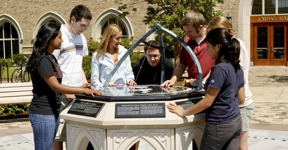
 View of the Jordan Hall of Science and the Notre Dame Dial from the top of the Notre Dame Stadium
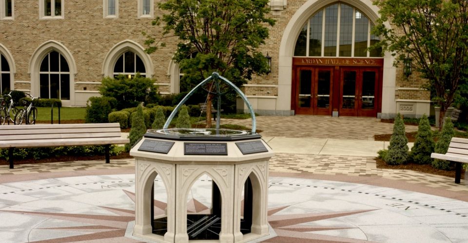 The design of the pedestal arches and the arms supporting the gnomon reflect the French Gothic style adopted for many buildings at Notre Dame
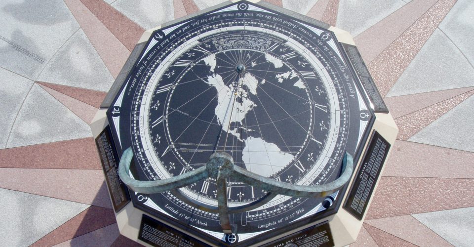 Birdseye view of Notre Dame Dial. The octagonal design was inspired by its use for baptistries in early Christian architecture
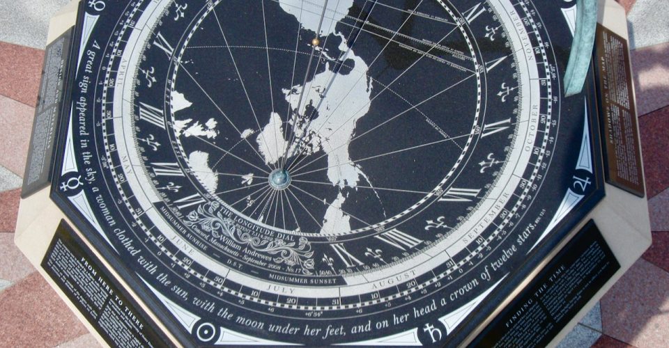 The inscription on the Notre Dame Dial comes from Revelation 1, verse 12, in the Bible
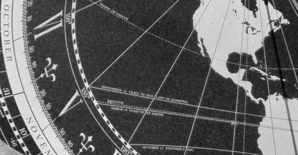 Detail of the map showing the three special occasion lines that the bead’s shadow will follow to commemorate those events on their appointed dates
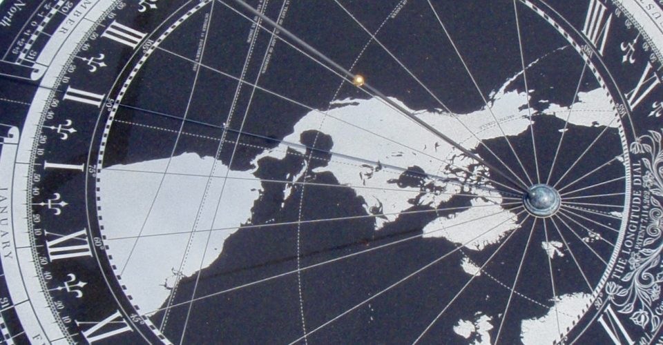 Detail showing the gnomon and its shadow
 With the beam of sunlight, the meridian line under the dial indicates the date, the hours of daylight and darkness, and the sign of the zodiac
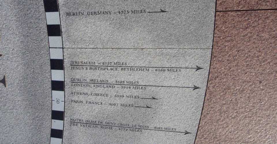 The compass rose shows the direction and distance of 84 places. Note that Notre Dame de St Croix and the Vatican, Rome, are in the same direction
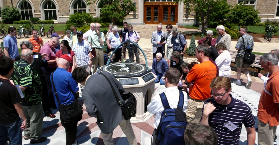 History of Astronomy Workshop delegates gather around the Notre Dame Dial to obverse the meridian crossing after a presentation in Jordan Hall
 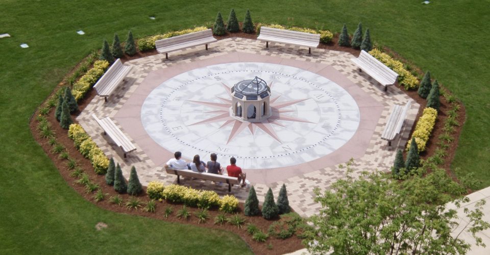 View from the roof of Jordan Hall
ORIGINS: The commissioning of this work by the University of Notre Dame was made possible through the generosity of Joseph I. O’Neill III, ’67 and his wife Jan to honor the memory of Joe’s roommate Michael P. Flynn (’67) and his brother Kevin P. O’Neill, ’69. The Notre Dame Dial is situated about 150 yards northwest of the Notre Dame Stadium outside the South entrance to the Jordan Hall of Science at latitude 41º : 42′ : 00.45” North and longitude 86º : 13′ : 54.63” West. The inscription around the perimeter is from Revelation 1, verse 12 in the Bible: “A great sign appeared in the sky, a woman clothed with the sun, with the moon under her feet, and a crown of twelve stars.”
SPECIAL OCCASIONS: On the map, the shadow of the gold bead marks the point on Earth where the Sun is directly overhead. As the Sun’s altitude varies during the course of the year, so does the latitude of the bead’s shadow. At the equinoxes, around March 21 and September 22, its shadow moves along the line of the Equator. At the summer solstice, around June 21, it eclipses the Tropic of Cancer. Three lines of special significance to Notre Dame have also been added: on March 19, the bead’s shadow follows the line that celebrates the Feast of St. Joseph. Likewise, on September 15, it traces the line of the Feast of Our Lady of Sorrows, and, on October 13, the Feast of St. Edward the Confessor, to commemorate Founder’s Day.
DESIGN: The gold-plated bead on the gnomon (the shadow-casting rod) marks the center point of the map projection and also the center of the three arms that support the gnomon: in the ancient geocentric concept of the heavens, this bead would represent the Earth at the center of the universe while the arms portray great circles of a celestial sphere. The concept of this design is based on an armillary sphere, an instrument employed during the Renaissance for teaching astronomy. The octagonal design was inspired by the use of the octagon in early Christian architecture for baptistries. Although its origins are unclear, it has been suggested that seven of the sides represent each day in the creation of the world and the eighth the rebirth through Jesus Christ. Following the traditional concept of the geocentric universe, each of the eight corners of the dial plate are engraved with a planetary symbol with Earth on the North corner and the Sun opposite on the South corner. The pointed arches of the pedestal reflect the French Gothic style, which, following its use in Notre Dame’s Basilica of the Sacred Heart, was widely adopted on campus.
MATERIALS: The dial plate and the meridian beneath are made from an igneous rock called gabbro, quarried in China. The pedestal was hand-carved from Indiana Oolitic limestone, a sedimentary rock found near Bedford, Indiana. The compass rose is composed of three kinds of granite, another igneous rock: the gray is from Barre, Vermont, the red from Wausau, Wisconsin, and the black degree scale from Bangalore, India. Inside the degree scale circle are arrows indicating the direction and the time of sunrise and sunset of special events connected with the history of the university, including the dates of the birth (at sunrise) and their death (at sunset) of eminent individuals and important occasions. The arrows on the outside of the degree scale show the direction and distance of 84 places on Earth associated with Notre Dame students and alumni. By a remarkable coincidence (or perhaps not!), Notre Dame de St Croix, the founding church of the Congregation of the Holy Cross, is in the same direction as The Vatican, Rome (see image above).
OTHER DETAILS: Note that the compass rose is angled slightly to the East of its octagonal terrace, which is aligned with the other buildings on campus. This difference of about 2.8º probably originated with the original land surveys of the 1840s being made with a magnetic compass, which would indicate magnetic North rather than true North.
University of Notre Dame
Notre Dame, Indiana 46556
Telephone: (001) 574 631 5000
Website: https://www.nd.edu
Opening remarks by the Provost, John Affleck Graves: https://www.youtube.com/watch?v=Gsq1DlWqlXU
 The Deerfield Dial stands in front of the entrance to the Boyden Library at Deerfield Academy
 View of the Deerfield Dial from the Boyden Library
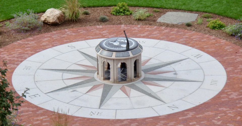 The compass rose is made of green granite from Lake Placid, NY, red granite from Wausau, WI, and gray granite from Barre, VT
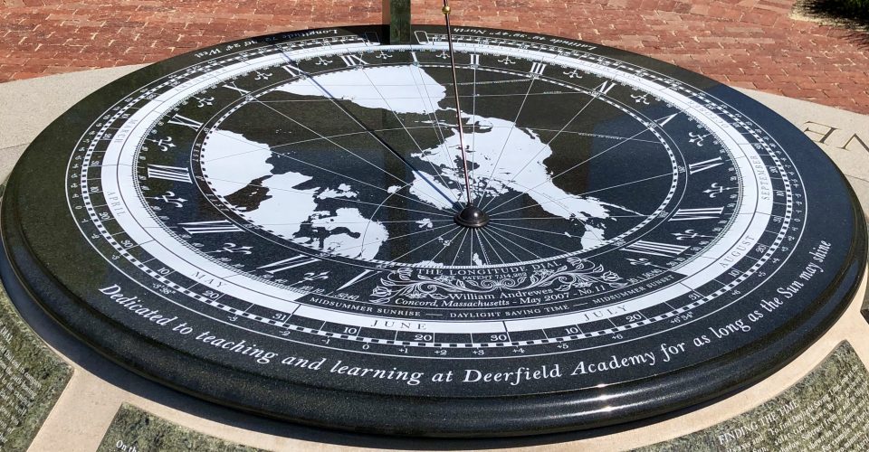 As well as a meeting point, the Deerfield Dial serves as a teaching aid in subjects such as astronomy, cartography, geology, and horology
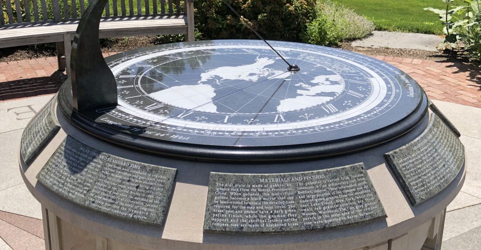 The pedestal was hand-carved from Indiana limestone, the information panels cut in conic sections from green granite from Lake Placid, New York
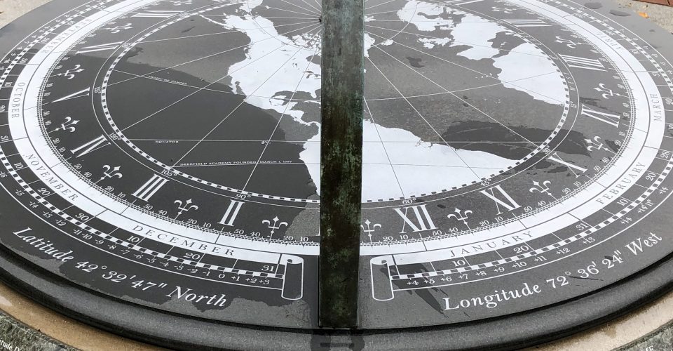 The engraved dial and meridian plates are made of gabbro, an igneous rock quarried in the Shanxi Province in China
 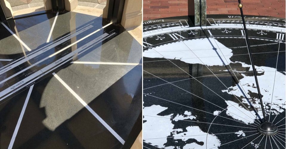 On a sunny day, watch as the Sun crosses the Deerfield meridian and the length of its beam beneath the dial shows the date and other information
 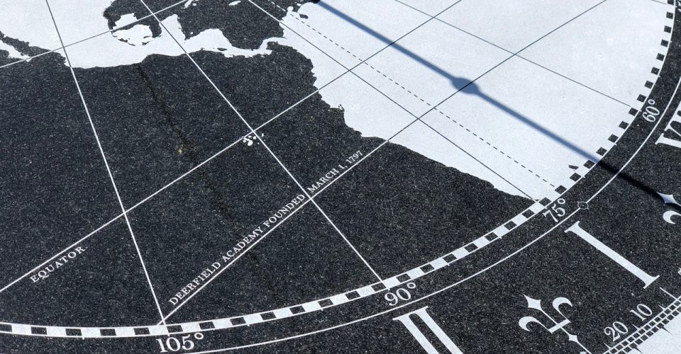 On March 1 each year, the shadow of the bead on the gnomon will follow the line commemorating the founding of Deerfield Academy in 1797
 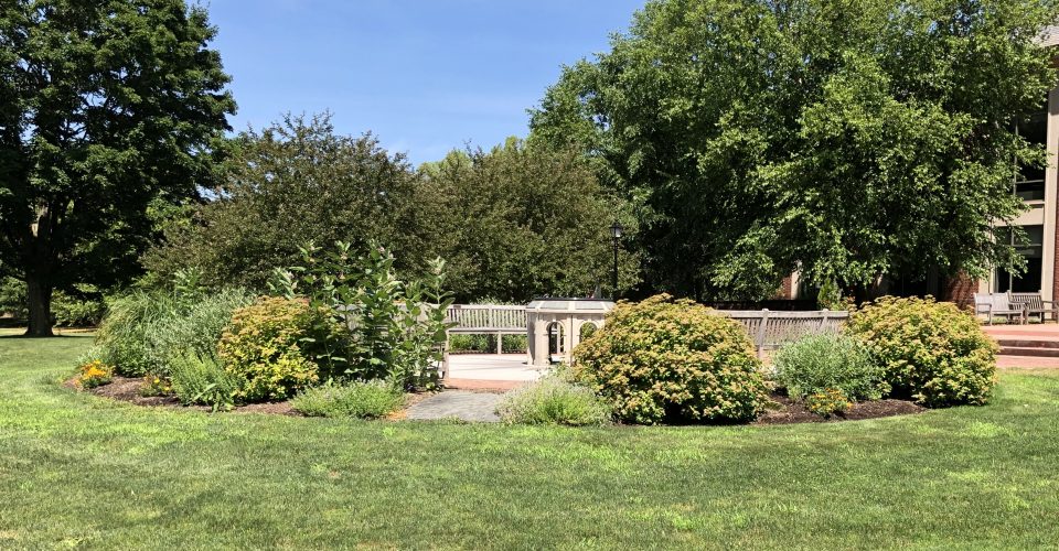 Looking West
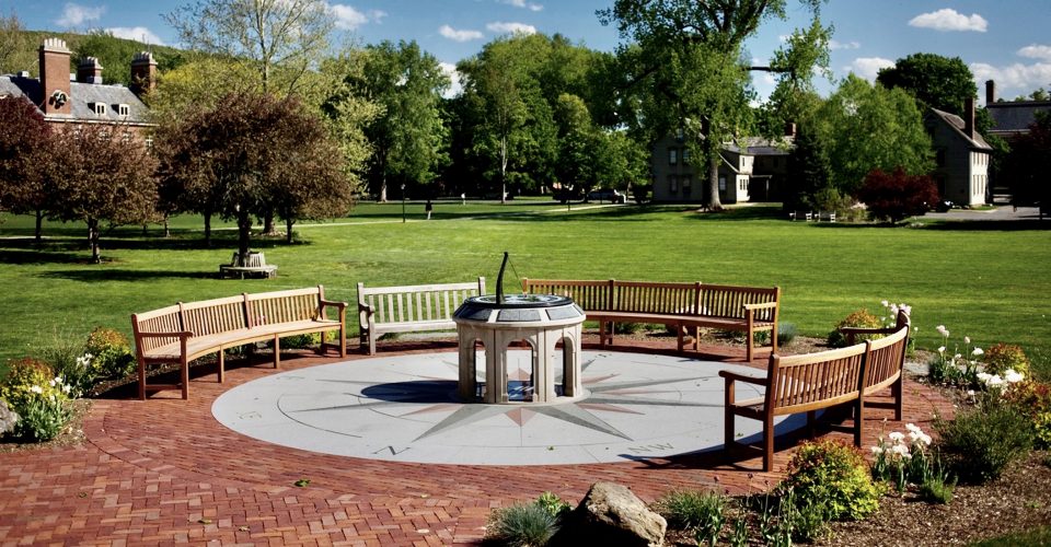 Looking southeast in the late afternoon after filming the Deerfield Dial for Hodinkee Magazine's documentary “Chasing the Sun"
ORIGINS: The commissioning of the Deerfield Dial took place in two phases.In 2006, the inspiration to site a Longitude Dial near the entrance to the new Koch Science Center originated with Brian Rosborough ’58, Academy Trustee. He proposed the inscription: Dedicated to teaching and learning at Deerfield Academy for as along as the Sun may shine. Together with fellow members of the Academy’s Board, Peter Gilson ’58, Jeff Lewis ’80, and Treasurer Michael Sheridan ’58, the design was approved, commissioned, and funded by David Koch ’58. The first location and a round brick pedestal, suggested by the architect of the Koch Center (under construction at that time) turned out to be unsuitable. In March 2011, the Head of School Margarita Curtis approved William Andrewes’s design for a new pedestal with a 30-foot compass rose at the entrance of the Boyden Library. The current installation began in March 2012 and was completed the following September. Three curved mahogany benches, designed and specially made to correspond to 14.5-foot radius of the compass rose were added at the end of the year. James and Sally Miller, parents of David ’97, Jonathan ’01, Elizabeth ’02, Alexander ’09 and Katherine ’12, helped to fund these developments. The Deerfield Dial continues to convene and inspire students and faculty for learning and fellowship in all seasons.”
DESIGN: The Deerfield Dial was designed for latitude 42º:32′:47.2″ North of the Equator and longitude 72º:36′:24.7″ West of the prime meridian at Greenwich, England. Deerfield Academy is located in the center of the map, identified by a small circle. The dotted line down the center of the map marks the Deerfield meridian and intersects the time scale at 11h:50m:24s. When the gnomon’s shadow crosses this line, it indicates the moment of local noon when the Sun is due South. The hour numerals on the Deerfield Dial are set for Daylight Saving Time, which is in effect for almost eight months of the year.
Before the advent of railroads, each town had its own local time, found by a sundial. The time at Deerfield was therefore different from any place to the East or West: local noon (when the Sun is due South) occurs just over six minutes earlier at Boston, about 80 miles East, and about four and a half minutes later in Albany, about 60 miles West.
The latitude of Sun’s path across the map changes with its declination during the course of the year. At the equinoxes, around March 21 and September 22, the bead’s shadow traces the straight line of the Equator. On the summer solstice around June 21, it eclipses the Tropic of Cancer. On March 1st, it will follow the line commemorating the day that Deerfield Academy was founded in 1797.
ORIENTATION: Note that the Deerfield Dial and its compass rose are angled about 8º from the path leading to the dial, which is parallel to the campus pathways and buildings to the East as well as to the main road along which the town was originally settled in 1673. That the direction of this road appears to bear no relation either to geographic North or magnetic North suggests that its original alignment was influenced only by the surrounding terrain.
MATERIALS: The dial plate is made of gabbro, an igneous rock from the Shanxi Province in China. The brass gnomon post and anchor have a dark green patina finish, while the gnomon is made of 316 stainless steel with a black passivate finish. The pedestal is carved from Indiana limestone, a fine sedimentary rock from Bedford, Indiana.
The information panels and large pointers of the compass rose are made of green granite from the mountains near Lake Placid, New York, while the small red granite pointers were quarried in Wausau, Wisconsin. The gray granite pavers in the main area come from Barre, Vermont. The cardinal letters on the compass rose are made of blackened brass.
Deerfield Academy
7 Boyden Lane, Deerfield, Massachusetts 01342
Phone: (001) 413-772-0241
https://deerfield.edu
 This image, taken on September 12, 2007, shows the Deerfield Dial in its original location on a brick pedestal designed by the architect of the Koch Center, which can be seen in the background
 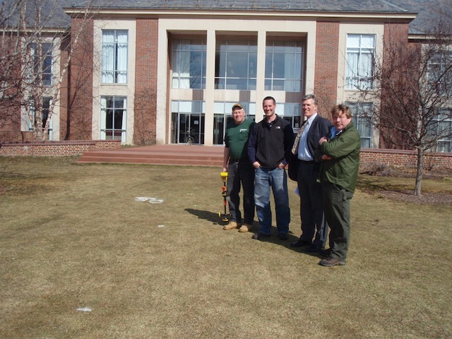 The new site in front of the Boyden Library was chosen in 2012. This photo, taken on March 8, 2012, shows some of the key people who helped to bring this to fruition. From left to right:
 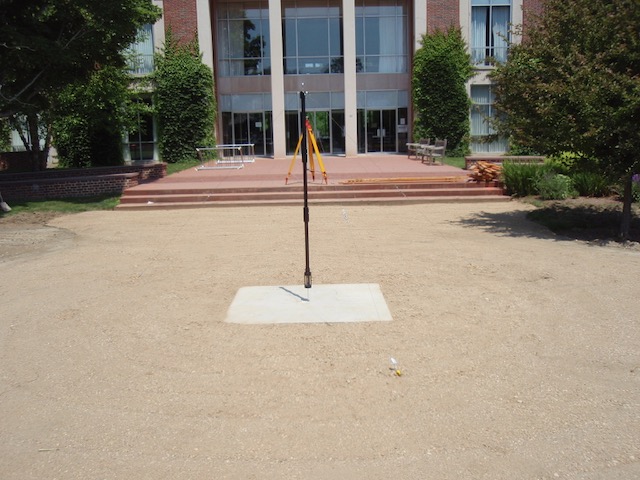 After the foundation had been prepared, a specially-designed instrument was used to determine the North-South line precisely
 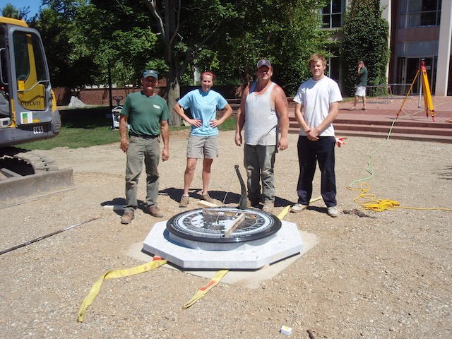 By July 3, 2012 when the Barre granite base and the gabbro dial plate had been aligned, the installation of the pedestal could proceed
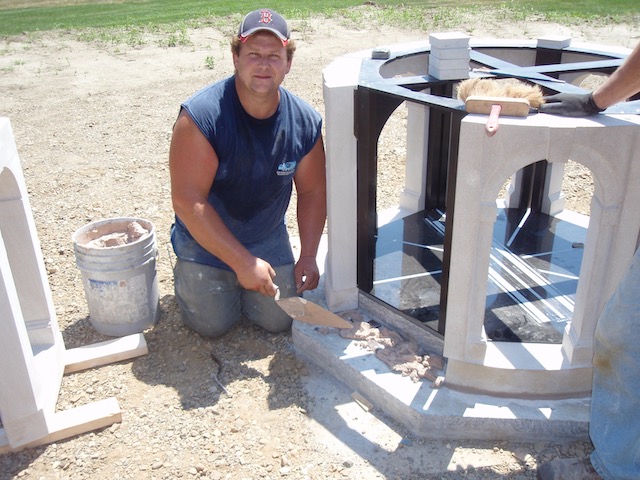 With the meridian plate and the pedestal frame accurately mounted, the eight curved section of the limestone pedestal were secured in place with mortar
  Gary Hahn, who engraved the dial and meridian plates, making some final adjustments to the pedestal assembly
 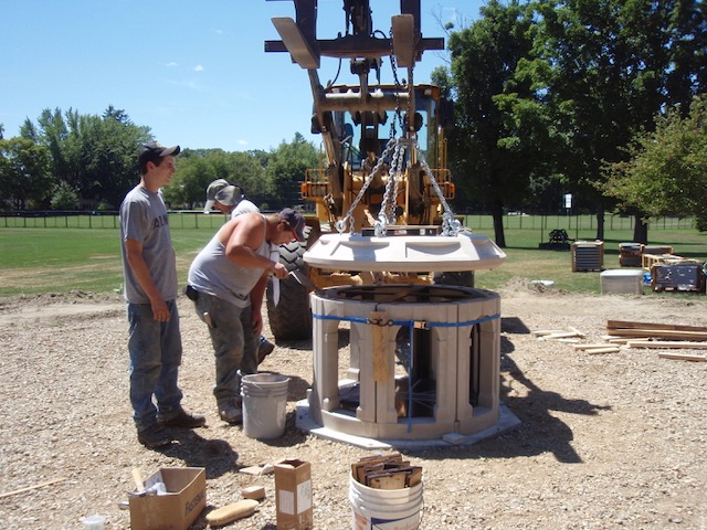 On July 25, the pedestal cap was lower into place, great care being taken to ensure that everything was aligned and level
 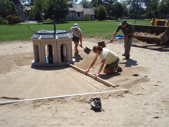 By July 30, the surrounding ground was being leveled and prepared for the installation of the compass rose and its surrounding brick terrace
 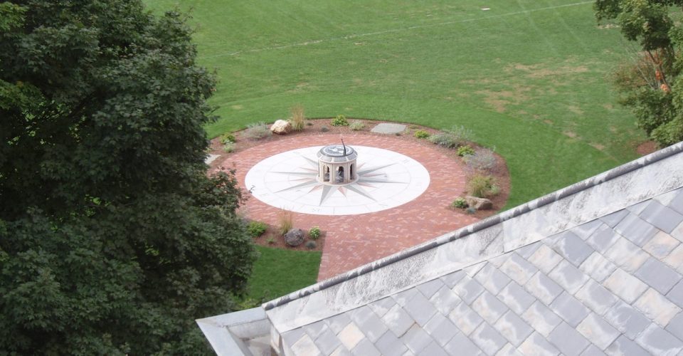 View of the completed installation of the Deerfield Dial, as seen on September 6, 2012, from the roof of the Boyden Library. Three mahogany benches, specially-designed to conform to the diameter of the compass rose, were added at the end of the year
 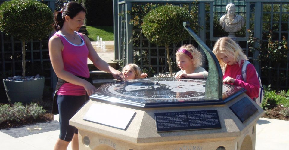 Located in the “Garden of Surprises” at Burghley House, the Burghley Dial fascinates adults and children of all ages
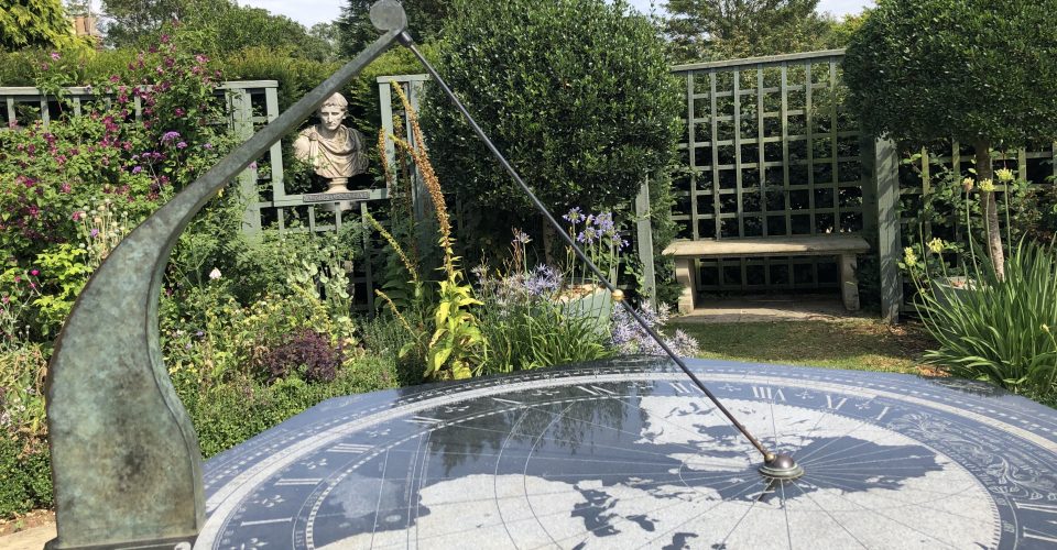 Looking East
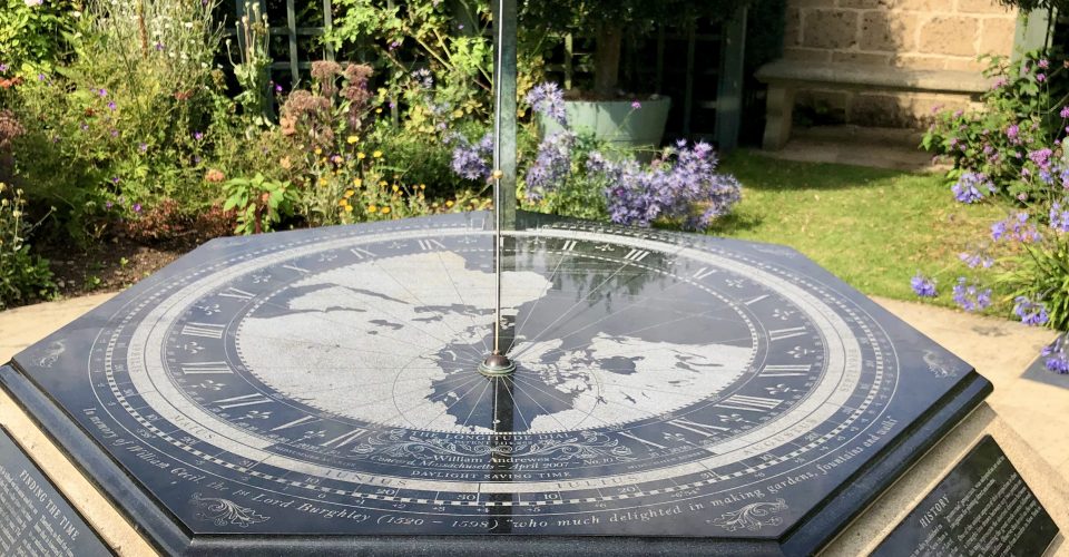 The inscription reads: "William Cecil, the 1st Lord Burghley (1520-1598) "who much delighted in making gardens, fountains and walks"
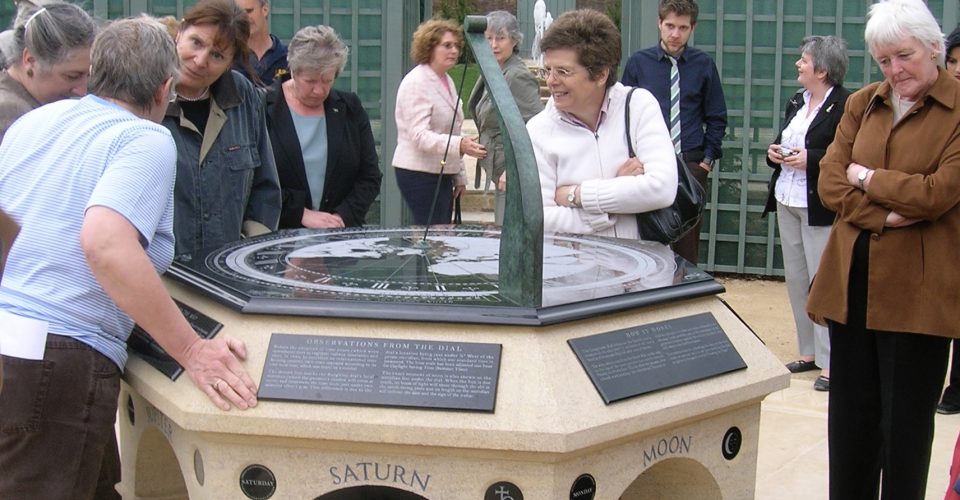 Friday, 27 April, 2007: the official opening celebration of the Burghley Dial (the Garden of Surprises was opened to the public on Sunday, April 1)
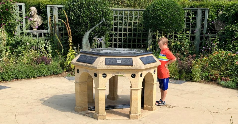 Learning how it works
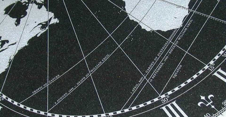 To commemorate William Cecil’s 500th birthday on 15th September, 2020, the gnomon bead’s shadow will trace the line marking that date
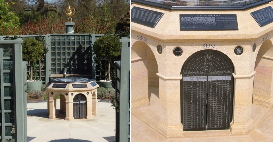 View from the South: the vertical slot in the engraved plate allows a beam of sunlight to shine at noon on the meridian line under the dial
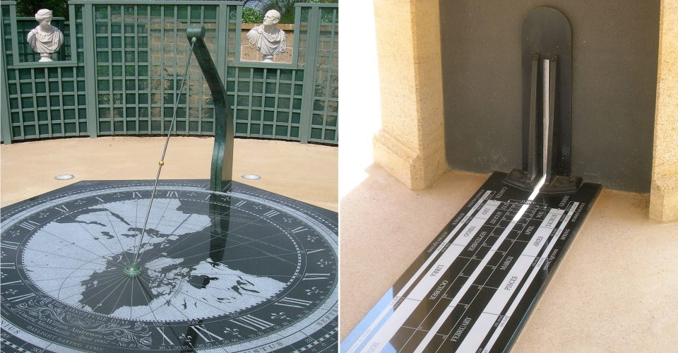 When the Sun is due South, the exact moment of noon is shown both on the dial and on the meridian beneath the dial
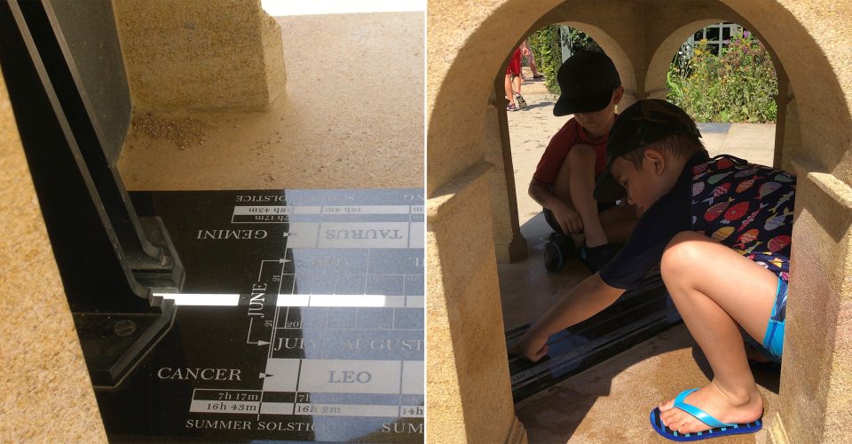 Getting a closer look: when the beam of sunlight crosses the meridian at noon, its length will tell you the date and the sign of the zodiac
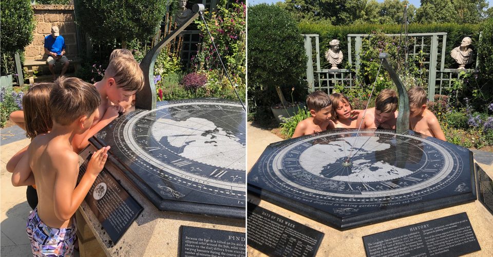 Watching the Earth rotate as the gnomon’s shadow moves
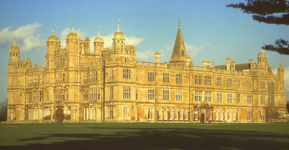 Burghley House, one of England’s grandest country houses, was built over a period of 32 years between 1555 and 1587
ORIGINS: The Burghley Dial was commissioned by Lady Victoria Leatham to commemorate the life and work of her ancestor William Cecil (1520-1598), the Lord High Treasurer and chief advisor to Queen Elizabeth I (1533-1603), who made him Baron Burghley in 1571. Burghley House was built between 1555 and 1587. The Burghley Dial is located in the Garden of Surprises, about 350 yards East of Burghley House, at latitude 52°:38’:32.25″ North, longitude 0°:26’:48.92″ West. The inscription around the edge of the dial plate reads: In memory of William Cecil, the 1st Lord Burghley (1520-1598), who much delighted in making garden, fountains and walks.
DESIGN: The dial’s pedestal is a heptagon, each side representing one of the planets from which the names of the seven days of the week evolved. Based on the ancient Egyptian concept of an Earth-centered universe, the planets — those seen with the naked eye (Sun and Moon included) — were believed to orbit the Earth in order of their perceived distance: Saturn (the most distant), Jupiter, Mars, Sun, Venus, Mercury, and Moon. Each hour of the 24-hour day was assigned to a planet, using the same order repeated consecutively for a period of seven days. Each day was named for the planet that governed its first hour: hence, Saturn’s day became Saturday, the Sun’s Day, Sunday, & etc. Since the planets were associated with mythological gods of different cultures, the day names vary linguistically: from Tiw, the old English name for the Nordic god Tyr, comes Tuesday. The equivalent Roman war god is Mars, from which mardi, martedi, and other related names derived.
MATERIALS: The dial, the meridian, and its vertical plate facing due South are made of gabbro, an igneous rock from China; the pedestal was carved by the stonemasons at Burghley House from a single block of Clipsham limestone that came from a nearby quarry; the pavers used for the compass rose are made of Yorkstone.
Burghley House
Stamford, Lincolnshire PE9 3JY, England
Telephone: (+44) 01780 752451
https://www.burghley.co.uk/
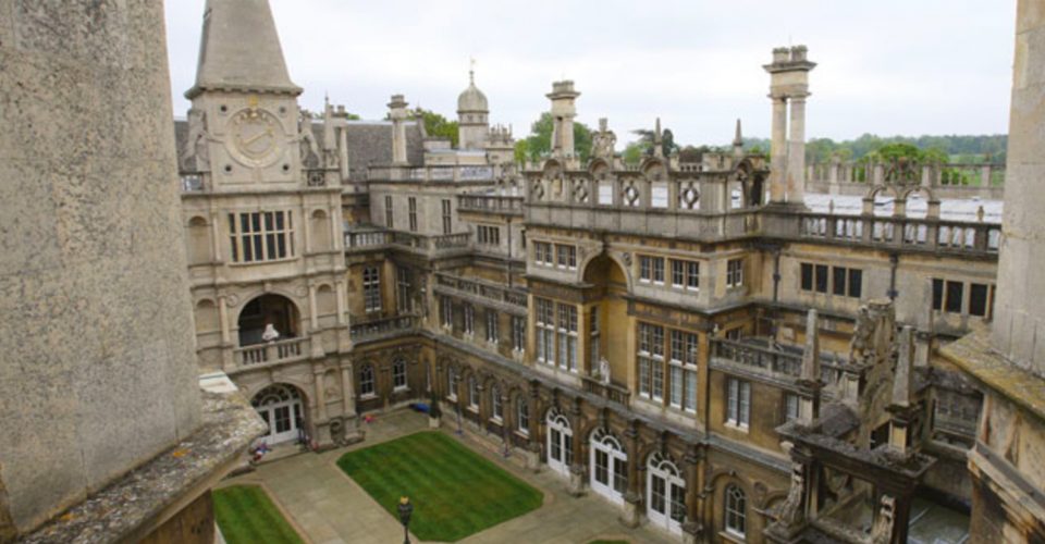 Inner courtyard of Burghley House
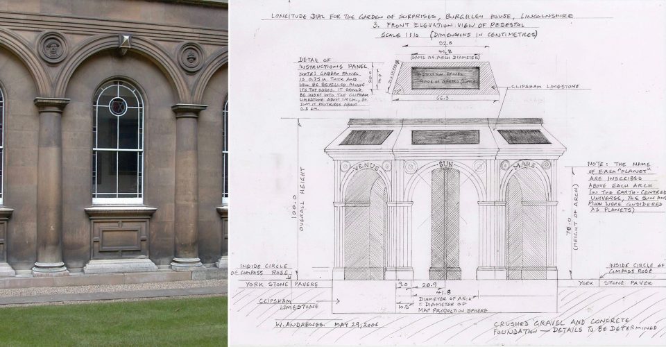 The inner courtyard window arches inspired the design of the pedestal arches and their spandrels.
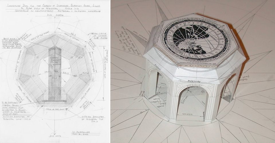 Plan view and model of the Burghley Dial. The dial’s seven sides represent the Sun, the Moon, Mercury, Venus, Mars, Jupiter, and Saturn after which the days of the week are named.
 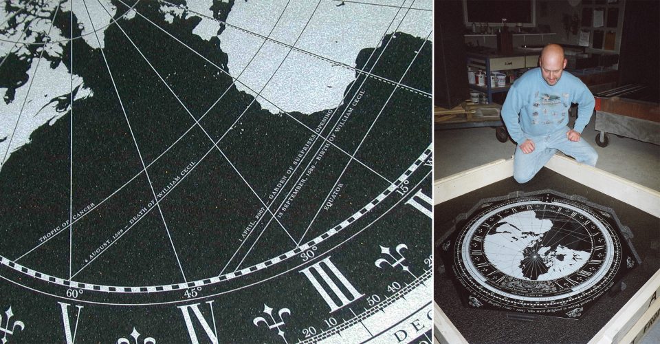 January 12, 2007: Detail of the gabbro dial plate with Gary Hahn, who did the engraving and assisted with the installation.
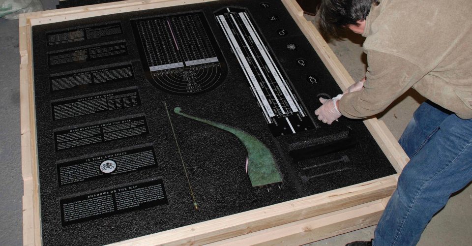 January 26, 2007: All the parts of the dial are finally ready for shipment from the USA to England.
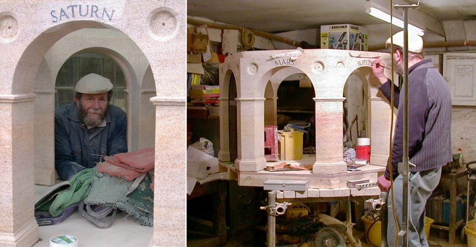 February 15, 2007: Gwyn Watkins, the chief stonemason at Burghley House, applying the finishing touches to the pedestal.
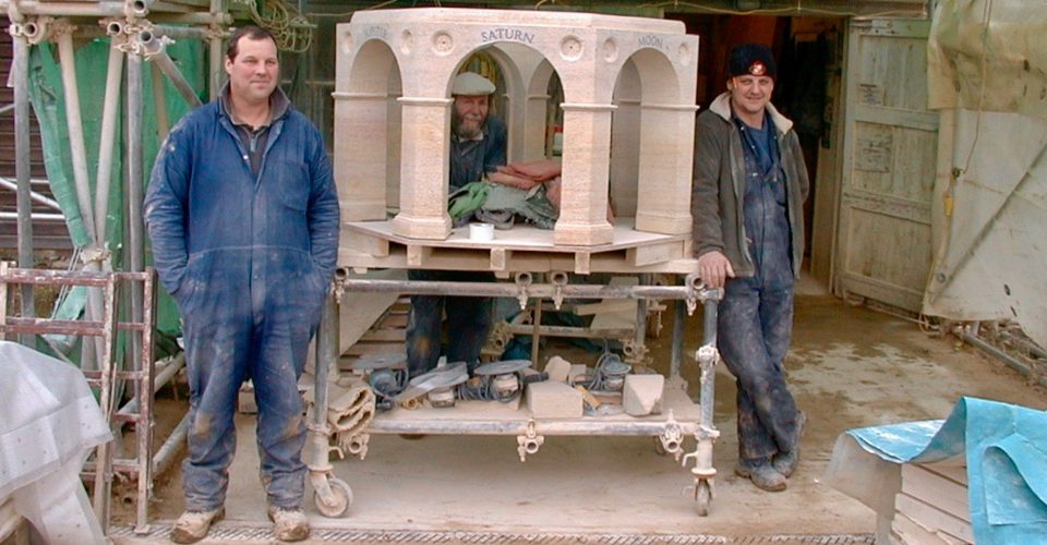 Stonemasons Grady Willis and Steve Sergeant, who worked with Gwyn to carve the pedestal and its arches from a single block of Clipsham limestone
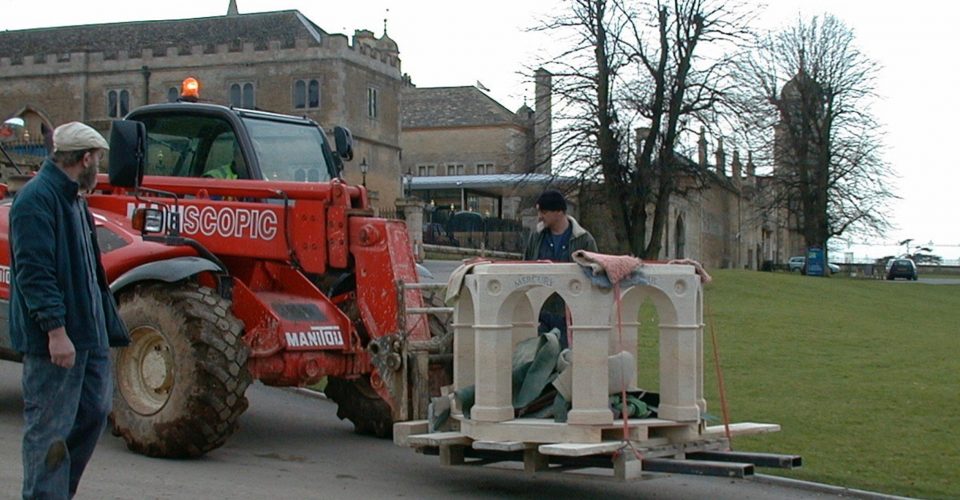 February 15, 2007: Gwyn and Steve keep watch as Mick Ford, the site foreman, transports the pedestal to the Garden of Surprises.
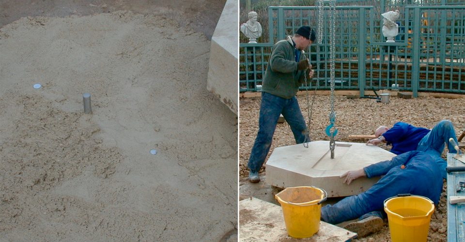 Two coins were placed in the mortar under the foundation stone before it was lowered in place.
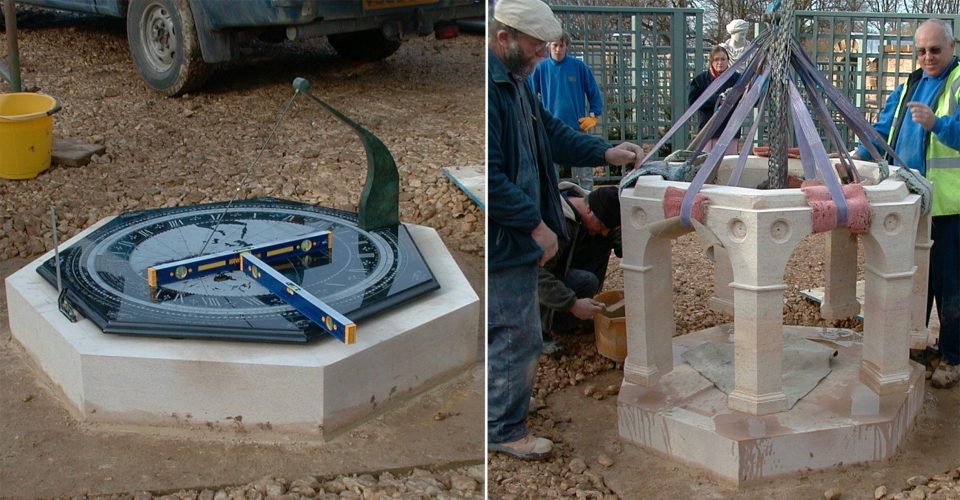 The foundation stone was leveled and precisely oriented with the dial plate before the pedestal was set in place.
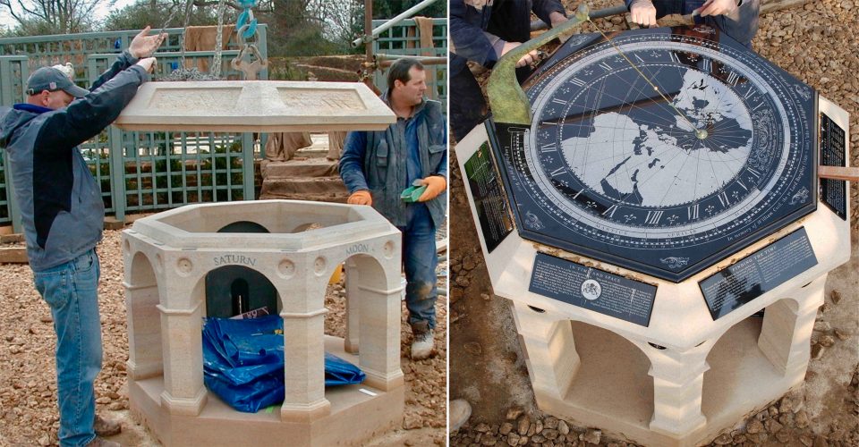 February 16, 2007: Lowering the pedestal capstone and setting the dial plate.
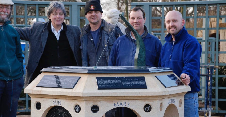 Tuesday, February 20, 2007: the day that the dial’s installation was complete: (l-r) Gwyn Watkins, Will Andrewes, Steve Sergeant, Grady Willis, and Gary Hahn.
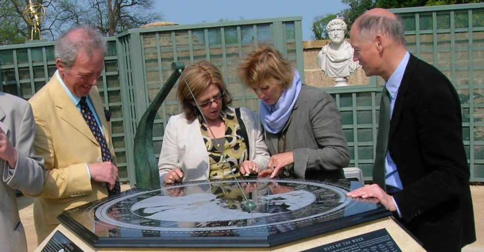 Finding the time with the Burghley Dial on opening day: Philip Ling (the Burghley House Estate Manager who helped to bring the commission to fruition), Libby Freeland, Charmian Ling, and Henry Freeland (of Freeland Rees Roberts Architects who assisted with the working drawings and overseeing the work on site) study the Burghley Dial under the watchful eye of the good Roman Emperor Antoninus Pius (86-161). The eight busts surrounding the dial in its enclosure were designed by the landscape architect to surprise visitors by moving periodically from side to side
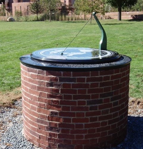
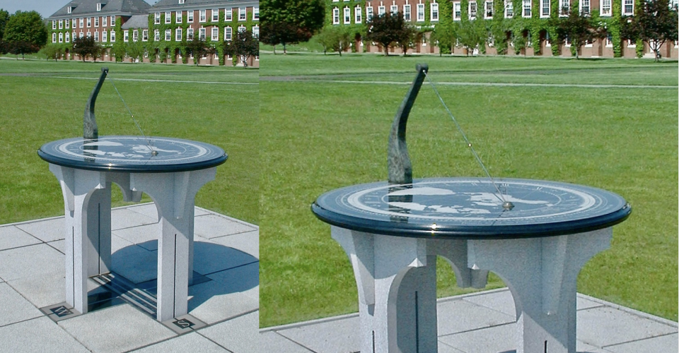 View of the Pomfret Dial looking Northeast
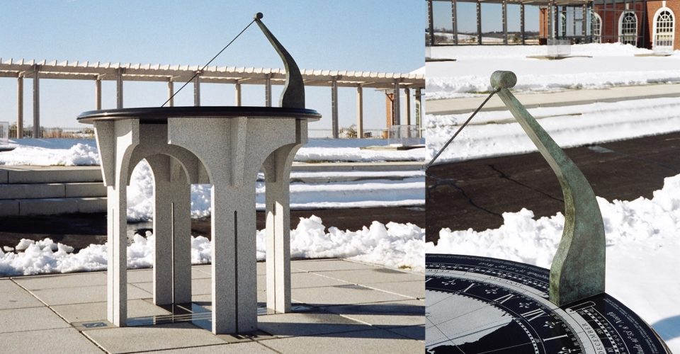 The gnomon post is made of patinated brass and the dial plate of gabbro, an igneous rock that absorbs the heat of the Sun and melts the snow
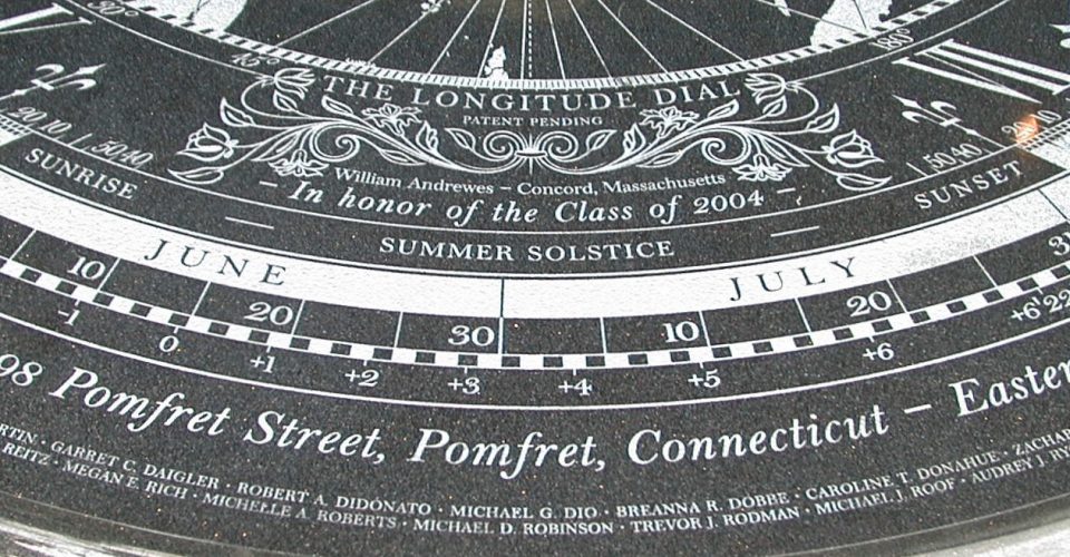 Detail showing the signature plate and, on the perimeter, the names of the 99 graduates of the Class of 2004 in whose honor this dial was made
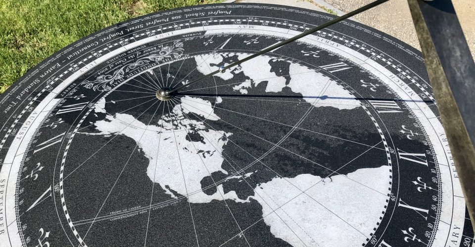 While the gnomon’s shadow indicates where noon is occurring on Earth, the bead’s shadow shows exactly where the Sun is overhead
 As the bead's shadow traces the Tropic of Cancer, clouds reflected in the dial move across the map, thereby showing which way the wind is blowing
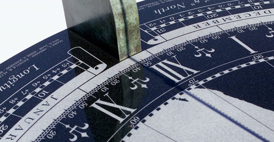 The gnomon's shadow indicates the time on the hour scale (11:46 am). On the degree scale and map, it shows that it is noon everywhere 78.5º West
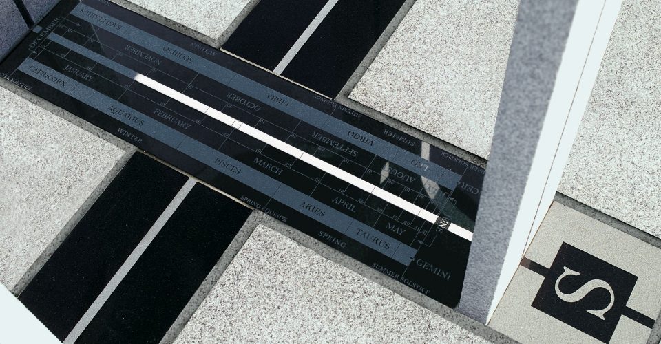 At noon, the Sun shines on the meridian line through the South-facing leg. The length of its beam indicates the date, sign of the zodiac, and season
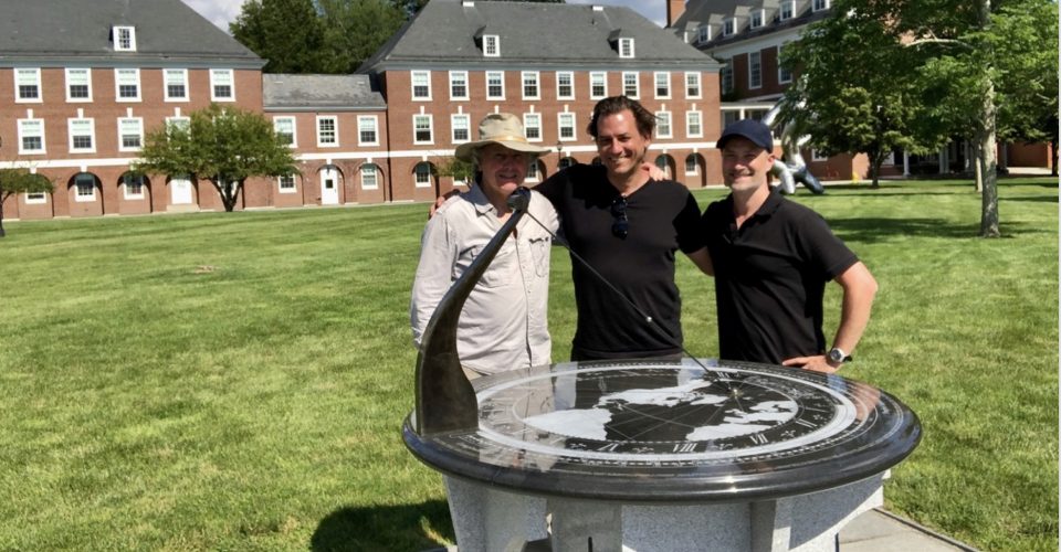 Will Andrewes with director Michael Culyba and cameraman Luke Geissbühler after filming the dial for the 2020 documentary "Keeper of Time”
ORIGINS: The Pomfret Dial was commissioned to honor the 99 graduating students in the Class of 2004. It is located in the quad behind the main school building, close to the Corzine Athletic Center and Olmsted Student Union, at latitude 45º53′:88.18” North and longitude 71º:57′:52.94” West.
SPECIAL OCCASIONS: The graduation of the Class of 2004 took place on Saturday, June 5. On that date each year, when the Sun is shining, the shadow of the gnomon’s bead will follow that line to commemorate that occasion.
DESIGN: The dial plate is about 47 inches in diameter and, on its pedestal composed of six interlocking sections of Barre granite, it stands about 42 inches high. It was the first “Monumental-style” Longitude Dial.
MATERIALS: The dial and the meridian plate are made of gabbro, an igneous rock from China; the pedestal and the surrounding paved area are made of Barre granite from a quarry in Barre, Vermont.
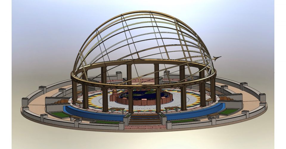 Sketch of the Chilpancingo Dial from the East: the armillary hemisphere arching over the dial supports the gnomon and its North-pointing arrow
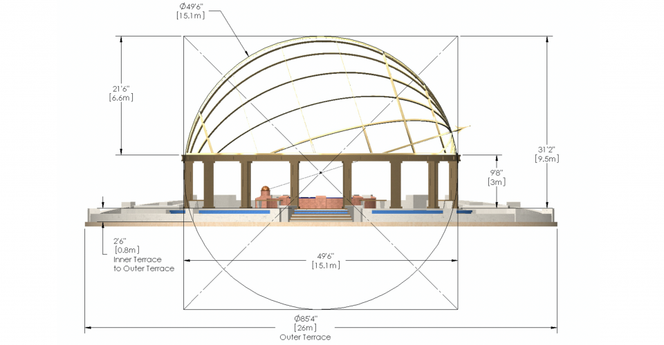 The armillary hemisphere, 15 meters (about 50 feet) in diameter and 9.5 meters (just over 31 feet) high, is supported on a circle of 16 columns
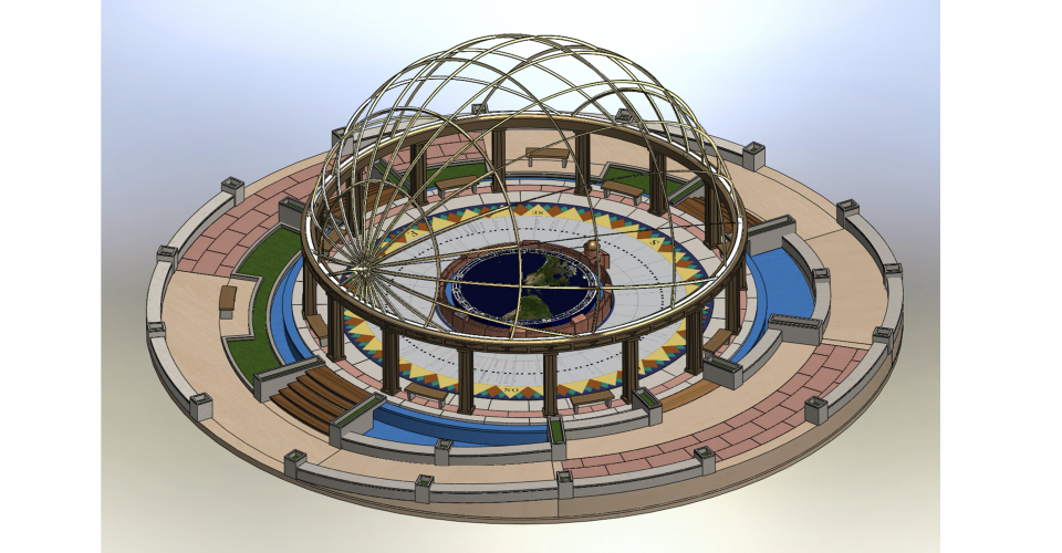 The compass rose is encircled by a waterfall and a moat to look like an island floating on water. Steps and bridges allow access from four directions
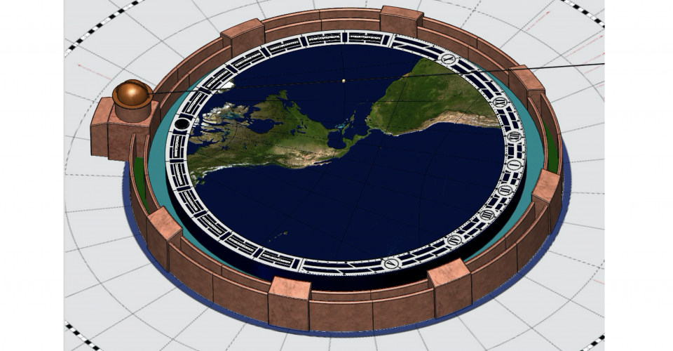 Water pumped into the oceans through the latitude and longitude lines flows under the five-meter diameter dial and off the edge in a waterfall
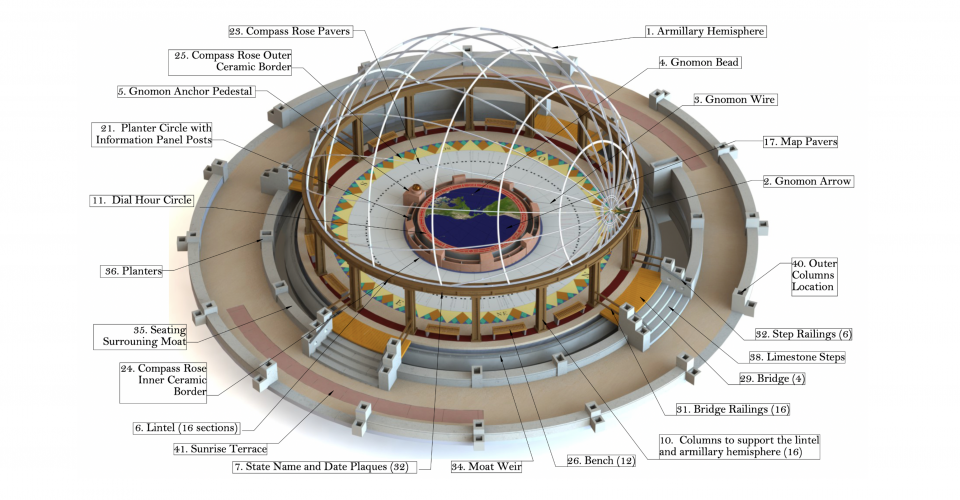 Drawing identifying the principal component parts of the Chilpancingo Dial
 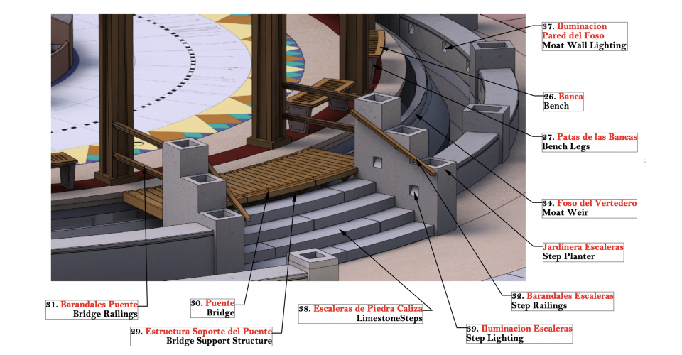 Detail of one of the steps and bridges that provide access to the dial and its compass rose terrace. Lights in the planters illuminate the way at night
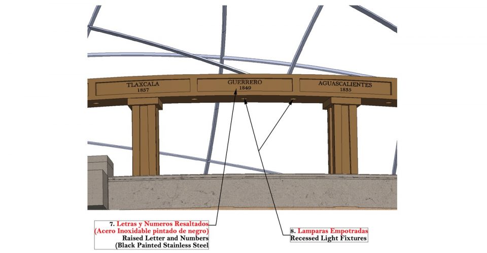 The lintel, which includes lighting to illuminate the compass rose at night, is inscribed with the name and date of statehood of each state in Mexico
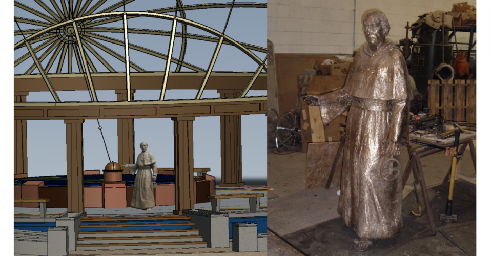 A life-size bronze sculpture of Andres de Urdaneta stands by the globe showing the sea route he pioneered in 1565 between Manila and Acapulco
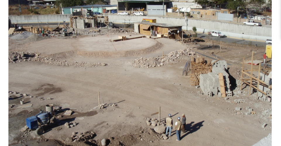 Construction on site began in August 2010. By January 27, 2011, the foundation had been laid. The vertical post marks the center of the dial
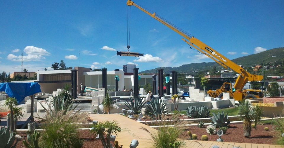
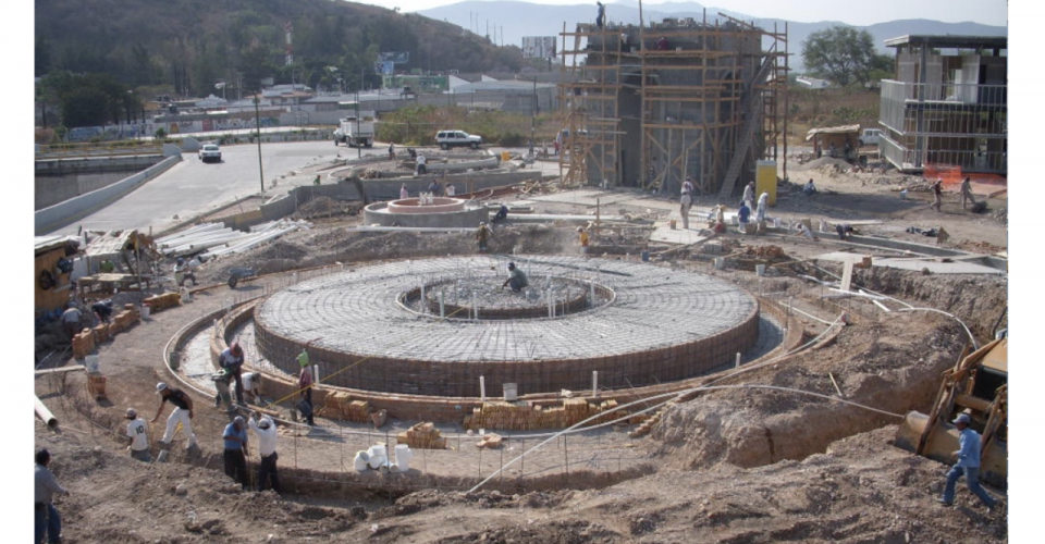 By March 15, 2011, the Dial and the Meridian Arch were well underway and the site was alive with activity
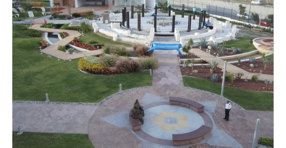 By September 14, 2012, all the columns had been bolted in place, but much work still had to be done on the dial, map, and armillary hemisphere
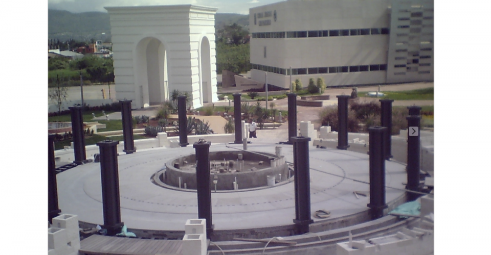 Work ceased when the new state government no longer made funds available. For several years, no further progress was made
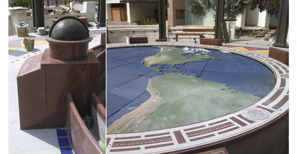 In 2016, a local builder was hired to continue the installation. Not understanding the design, the dial and map were installed the wrong way round
 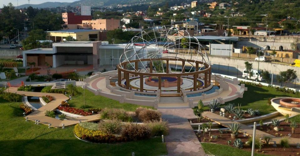 Visualization of the completed dial with the armillary hemisphere installed. With the required funds, this project could still be brought to fruition
ORIGINS AND HISTORY: In January 2007, Enrique Pasta, the Director of Administration and Finance in the Department of Education in Guerrero, saw Dava Sobel’s article “Sunny Side Up,” which had recently been published in the Patek Philippe Magazine (see “Media” section above). At that time, Mr. Pasta was looking for ideas for a suitable monument to commemorate the bicentenary of Mexico’s declaration of independence from Spain, a long struggle in which Guerrero and its capital Chilpancingo had played a significant role. A sundial, particularly one that would feature Chilpancingo in the center, seemed worth pursuing, so, in early April 2007, he invited William Andrewes for his first visit to discuss ideas and a possible location at the Governor’s Palace.
When Andrewes asked him how large the dial should be, Mr. Pasta suggested five meters, so that became the scale on which the project developed. Soon after the first design was submitted, the decision was made to change the location and create a Bicentennial Park that could be enjoyed by the general public. An area adjacent to the future home of the State of Guerrero Judiciary buildings was approved by Governor Zeferino Torreblanca, and Architect Jorge Madrigal and his associates began developing the site. In March 2010, the Federal Government of Mexico approved funding for the entire project, which included a completely new design for the Chilpancingo Dial and for a Bicentennial Arch with a meridian at the park entrance. Construction progressed rapidly, but in April 2011, a new governor was elected and the funds were gradually used for other projects. Letters written by Senator John Kerry (who subsequently became Secretary of State) and colleagues at Cambridge University, Harvard, and MIT, and an article by Felipe Fernandez-Armesto published in El Mundo (Madrid, Spain) encouraged the new administration to continue the project, but by 2013, the work on site came to a standstill when no further funds were made available. Despite countless emails and every effort by Enrique Pasta, the situation did not change.
Thankfully, the Bicentennial Arch and its meridian (see “Chilpancingo 2” above) were completed before these political upheavals took place. Between November 2017 and March 2018, Chilpancingo Dial’s design was displayed in the exhibition “Globes” at the Palais de Chaillot in Paris. Yet even with this international recognition, the site remains abandoned and unfinished. Only with additional financing will it be possible to complete this public monument to Mexico’s independence.
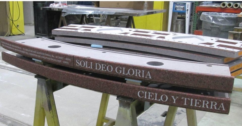
SPECIAL OCCASION: Cielo y Tierra (Heaven and Earth), the name given to the Chilpancingo Dial, was designed and constructed to commemorate the bicentenary of the Congress of Chilpancingo at which Mexico’s first declaration of independence was ratified. The Congress took place in the Catedral de Santa María de la Asunción in Chilpancingo. It was there, on September 13, 1813, that José María Morelos presented his Sentimientos de la Nación (“Feelings of the Nation”), a now famous document that laid out the principles of a constitution to establish Mexico’s independence from Spain.
This monumental sundial was chosen to mark the bicentenary of this seminal event in Mexico’s history, because it combines two elements linking the past and the present: astronomy (which played such an important role in the pre-Columbian world) and time measurement (a foundation stone of our present civilization).
DESIGN: With the armillary hemisphere (representing the heavens) arching over the dial (symbolizing Mother Earth), it illustrates the universe known to the Olmecs, Aztecs, and other ancient civilizations, and hence its name: Cielo y Tierra.
The five-meter diameter hour ring encircles the map, and the water in the oceans flows off the edge into the surrounding channel. The fifteen-meter armillary hemisphere arching over the dial supports the gnomon, the shadow casting wire that indicates the time on the hour circle. The compass rose terrace has been designed to appear like an island, echoing the original island city of Tenochtitlan, the capital of the Mexica civilization. The water surrounding the compass rose flows from under its perimeter into the waterfall and moat. Like the causeways that connected Tenochtitlan to the mainland, steps and bridges provide access to the sundial from the North, East, and South, and ramps lead up to the West entrance.
Located in the Bicentennial Park, Chilpancingo, Guerrero, Mexico at latitude at 17º : 31′ : 8.90” North and latitude 99º : 29′ : 4.53” West.
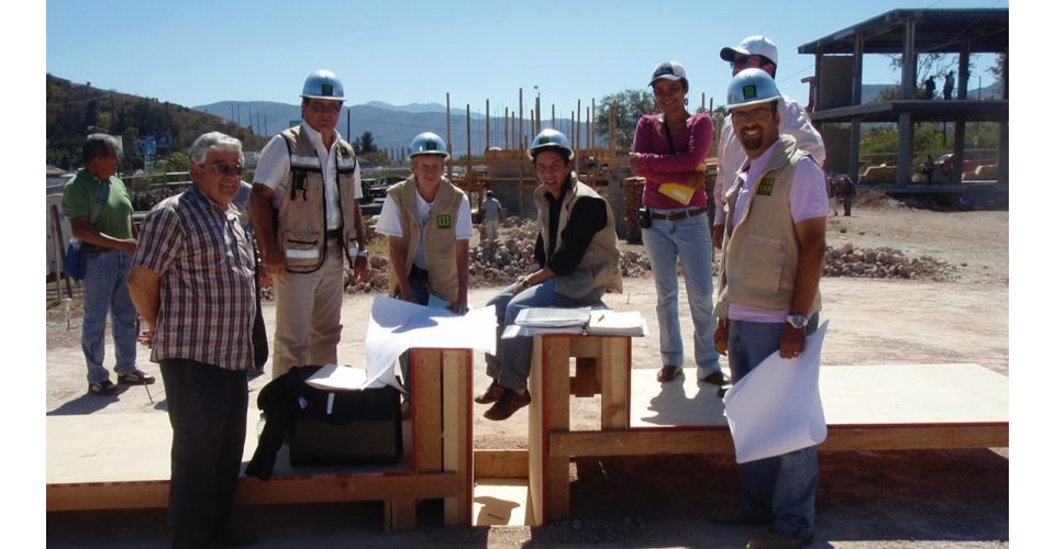
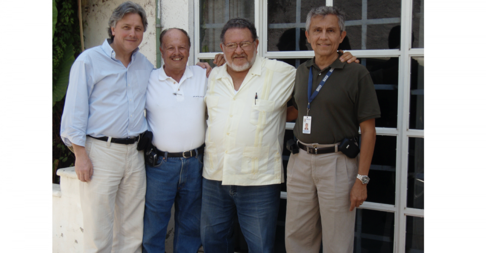 Will Andrewes, Luis Morfin, Emilio Quezada, and Enrique Pasta on April 7, 2008. Enrique Pasta, who was in charge of administration and Finance in the Department of Education in Guerrero, had originated the commission for the Chilpancingo Dial in 2007 and been appointed by Governor Zeferino Torreblanca to direct the project. Luis Morfin and Emilio Quezada were brought in to advise on historical matters
 May 7, 2010: Enrique Pasta and Jorge Madrigal at the reception in the USA celebrating the move from design to construction. The special cake is surmounted by the model of the Chilpancingo Dial
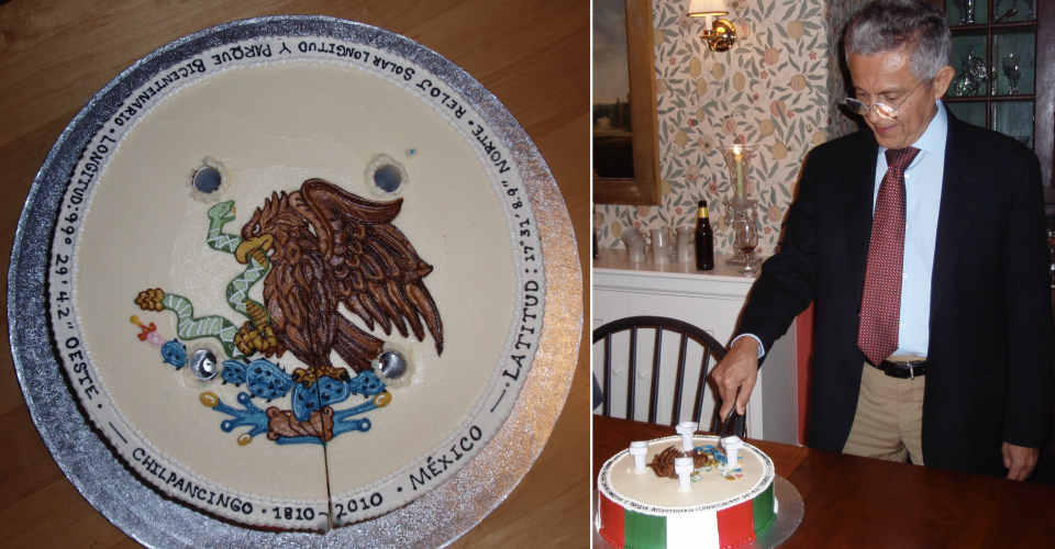 The cake was decorated with the coat of arms of Mexico and inscribed with the date when Mexico's war of independence from Spain began (1810) and the date when the building of the Chilpancingo Dial, celebrating the bicentenary, commenced (2010)
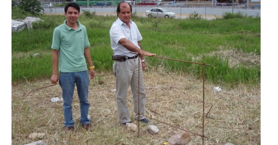 August 12, 2010: Jorge Madrigal and his assistant Luis Chavez showing where the center of the Chilpancingo Dial and the elevation of its compass rose will be
 January 27, 2011: Jorge Madrigal (second from left) and with the leaders of his construction team on site, including Oscar Ferro, the chief foreman (far right)
 April 15, 2011. While survey details of the dial are checked, the surrounding construction of the moat continues
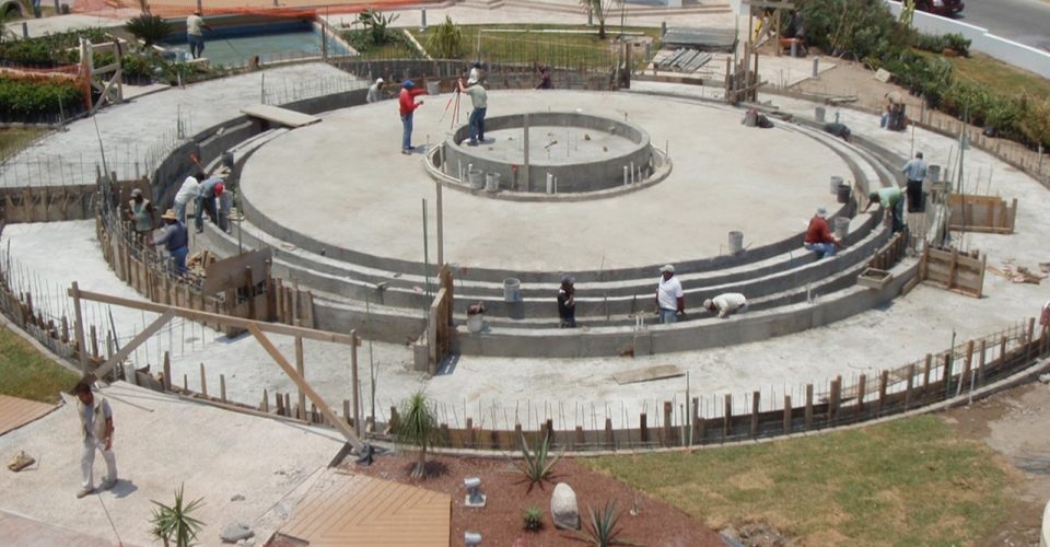
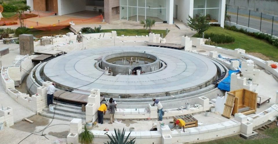 September 8, 2012: with the compass rose pavers and the bridges over the moat installed, the construction of the perimeter limestone walls and planters gets underway
 September 13, 2012. The columns that will support the armillary hemisphere are set in place
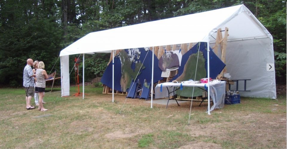 August 18, 2013. Gary and Karen Hahn with Cathy Andrewes and the studio tent that Gary set up in his backyard to paint the map sections, made of Barre granite
 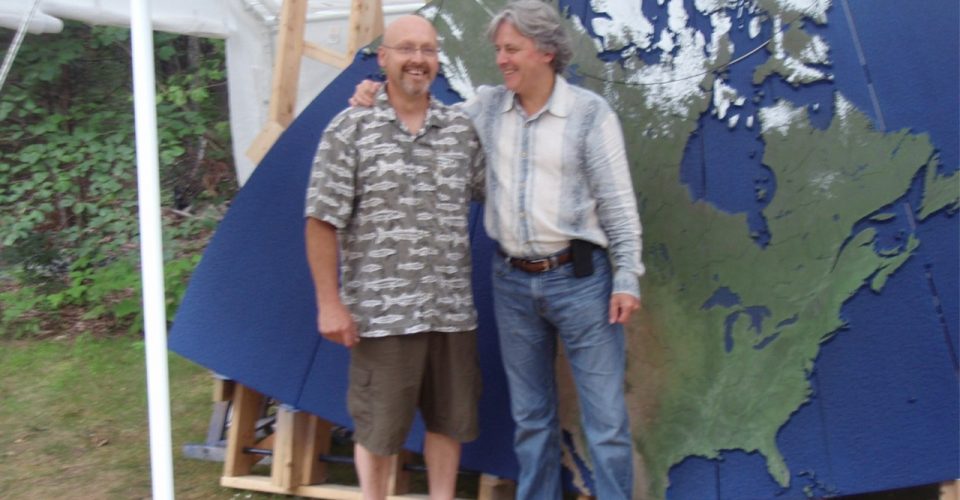 August 18, 2013. Will Andrewes congratulates Gary Hahn, who painted the 27 sections of the map using satellite images of the Earth from space
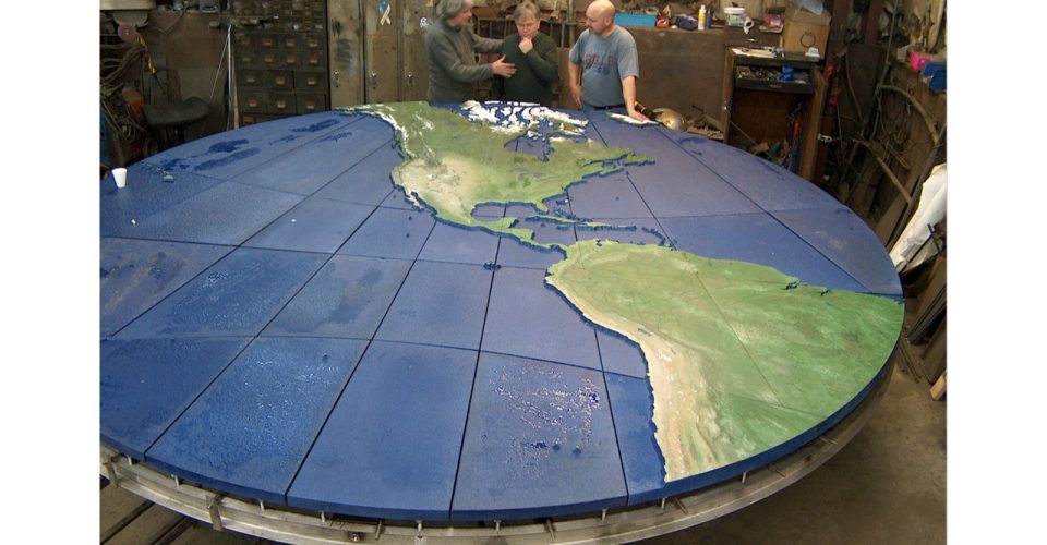 November 21, 2013: Will Andrewes, Peter Cassidy, and Gary Hahn in the Cassidy Brothers workshop, where the steel frame supporting the map sections was made. After everything was checked, the entire assembly was shipped to Mexico
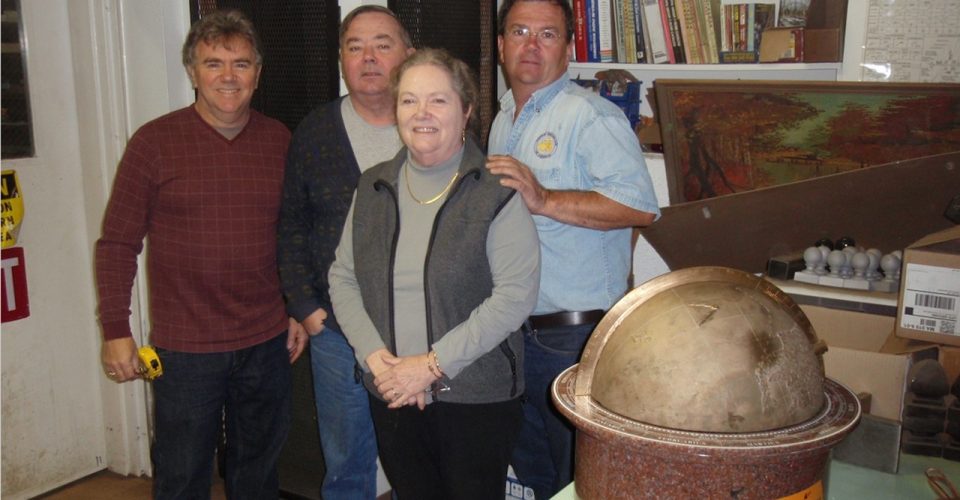 Peter, Maurice, and Vincent Cassidy with their sister Sue Lucey of Cassidy Bros., the company that made all the ironwork for the Chilpancingo Dial
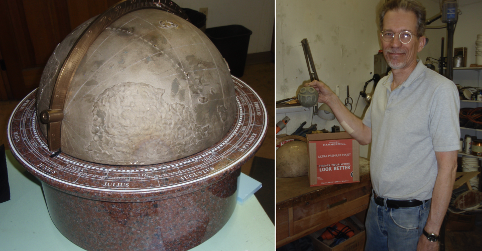 The globe, modeled and cast in bronze by Jim Montgomery (founder of New England Sculpture Service). The design, based on the original 1547 Mercator globe in the Harvard Map Collection, is marked with the course of Andrés de Urdaneta's famous voyage from Manila to Acapulco in 1565
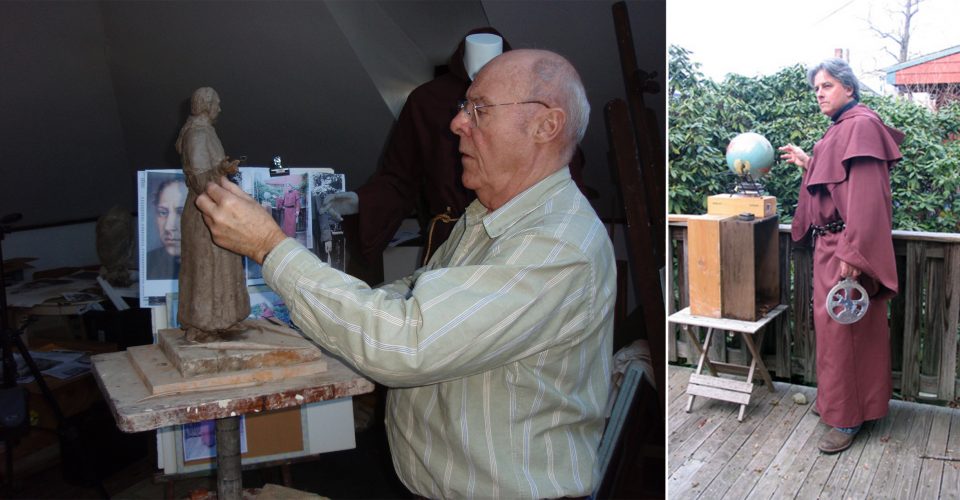 Lloyd Lillie working on the maquette of the statue of Andrés de Urdeneta, the Augustian monk who pioneered the trade route between Manila and Acapulco in 1565. Lloyd hired the appropriate attire and asked Will Andrewes to demostrate the desired pose with a mariner's astrolabe, the latitude-finding instrument that was used by the Spanish at that time
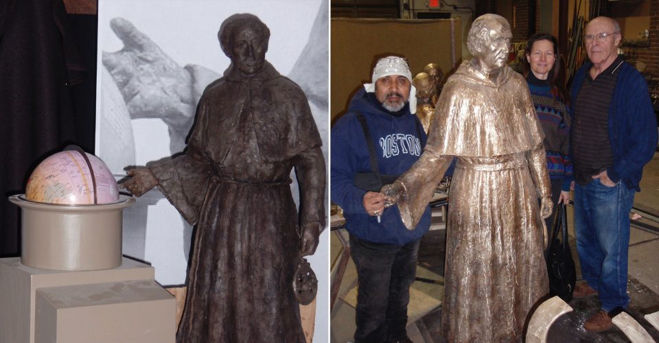 Full size wax model and completed sculpture of Andrés de Urdaneta with Lloyd Lillie, Vicky Guerina, and Raphael at the New England Sculpture Service on January 14, 2011. Raphael was responsible for the finishing of the bronze
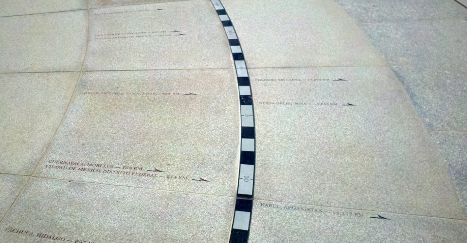 Detail of the Chilpancingo compass rose, showing the arrows indicating the direction and distance of all the state, capitals in Mexico and many other major cities throughout the world
 Gary Hahn, Will Andrewes, and Peter Cassidy at the end of their last installation visit on September 14, 2012
 All the missing parts required for the installation of the gnomon anchor, the dial plate, and the map had arrived on site by February 18, 2014. When action to install them was finally taken in November 2016, no attempt was made to seek advice
 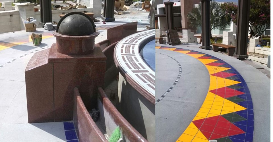 In order for the shadow of the gnomon to fall in exactly the right place, the precise elevations of the gnomon anchor, the dial plate, and the map are critical. Those responsible for their assembly did not understand this. For the dial to work correctly, these parts will need to be taken apart and reinstalled
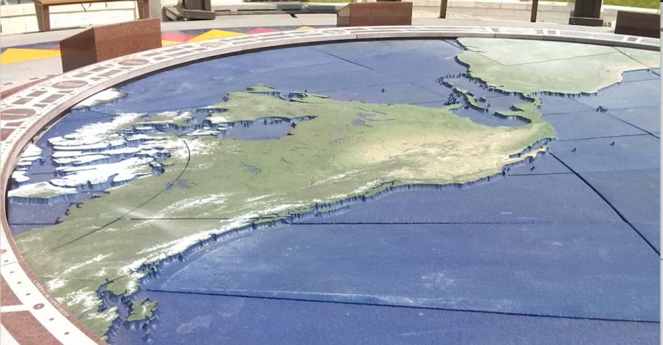 In November 2016, the dial and the map were also installed the wrong way round, because no one asked advice on their correct orientation
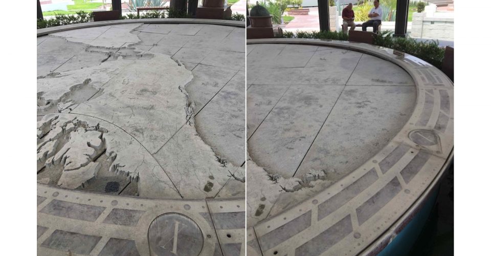 By May 24, 2017 when this photograph was taken, the dial plate had become covered in dust from nearby construction. So long as these parts have not been mortared in place however, with careful cleaning, it should be possible to reinstall everything correctly
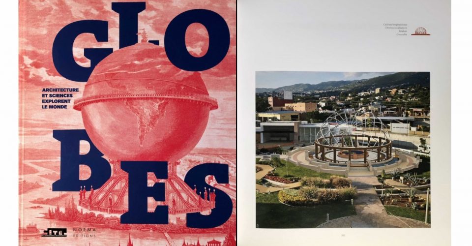 For an unfinished work, the Chilpancingo Dial has received a remarkable amount of international publicity. In addition to Felipe Fernández-Armesto’s 2012 article in the Spanish newspaper El Mundo (see “Media" section above), the design of the Chilpancingo Dial was featured in the exhibition “Globes: Architecture et Sciences Explorent le Monde” held at the Cité de l’Architecture & du Patrimoine in the Palais de Chaillot in Paris between November 9, 2017 to March 26, 2018. The images below show the cover of the exhibition catalogue by Yann Rocher and one of the pages illustrating the Chilpancingo Dial
 The entrance to Chilpancingo’s Cathedral, where Mexico's first declaration of Independence was signed, inspired the design of the Bicentennial arch
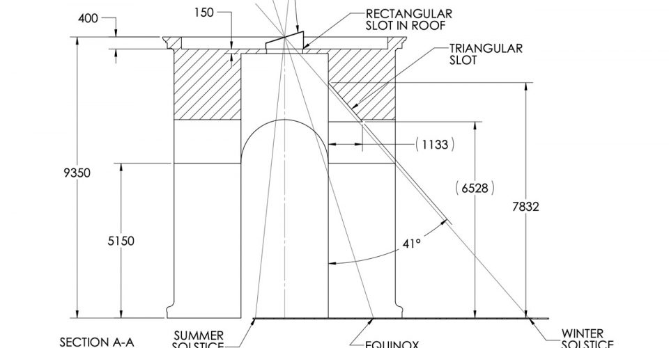 The four-sided Bicentennial arch includes a meridian that, with a single beam of light at noon, tells the date and related astronomical information
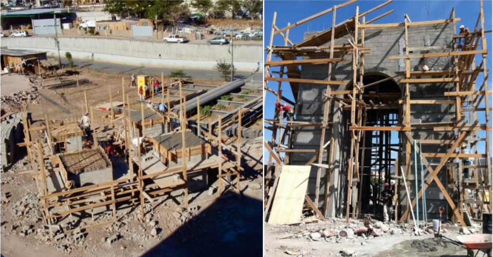 Construction of the arch at the entrance to the Bicentennial Park began in January 2011 and took about three months to build
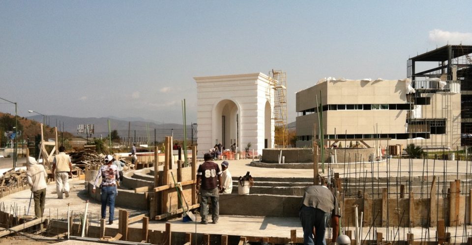 By mid-April 2011, the arch was ready for the installation of the meridian line, the North-South line that runs through its center
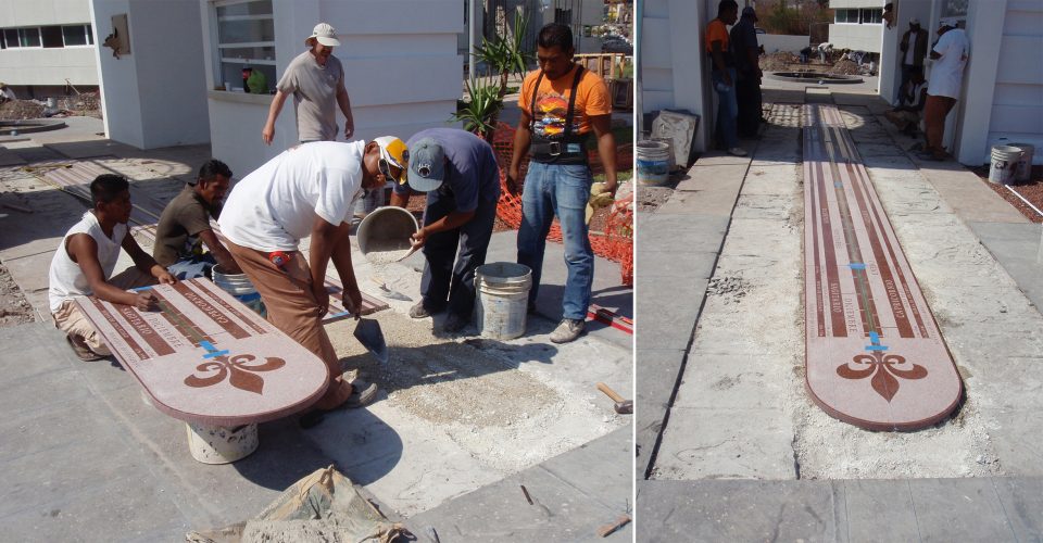 By April 16, the team were installing the final sections of the meridian’s engraved Wassau red granite pavers
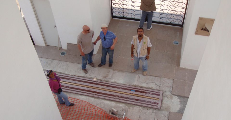 By noon, the work was complete and observations of the beam of sunlight on the meridian were underway
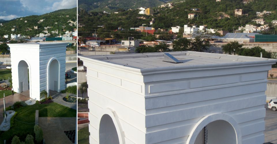 Chilpancingo Dial, arch aperture
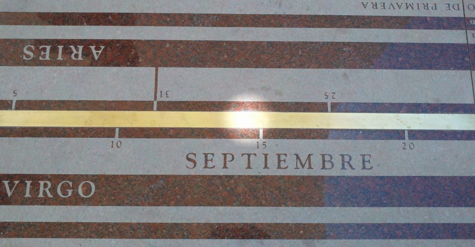 Chilpancingo meridian, showing the beam of light at noon on September 14, 2012
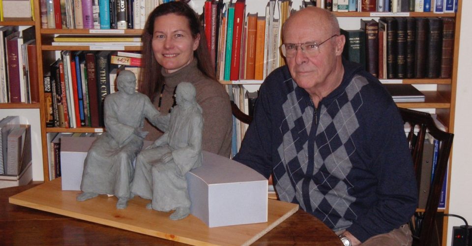 Lloyd Lillie and his former student Vicky Guerina, seen here with the maquettes, were commissioned to model the sculptures of Hidalgo and Morelos
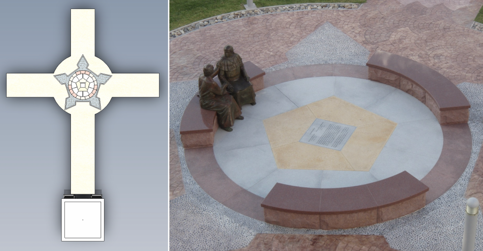 The path from the Bicentennial Arch was designed as a crucifix to signify the Christian influence in the fight for Mexico’s independence from Spain
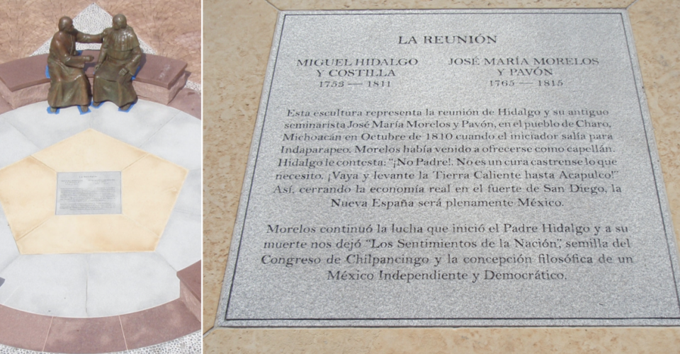 Hidalgo instructed Morelos: "Go to la Tierra Caliente, get the people up in arms, and take the Fort of San Diego in Acapulco!"
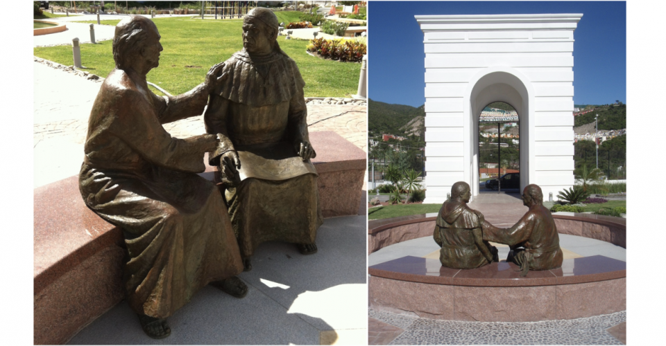 Priest Miguel Hidalgo persuaded his student José Maria Morelos to capture Acapulco’s fort, a key stronghold in Mexico’s struggle for independence
ORIGINS: In 2009, the decision was made to relocate the Chilpancingo Dial from the site originally proposed in the courtyard of the Governor’s Palace (Palacio de Gobierno del Estate de Guerrero) to an undeveloped area about one mile southeast, close to the main highway between Mexico City and Acapulco. Enrique Pasta, who had been appointed by Governor Zeferino Torreblanco to direct this project, hired an experienced architect Jorge Madrigal to develop the site into a Bicentennial Park to commemorate the Congress of Chilpancingo, where Mexico’s first declaration of independence from Spain was ratified on September 13, 1813. The Congress took place in Chilpancingo’s Cathedral (Catedral de Santa María de la Asunción de Chilpancingo). The grand arched entrance to this cathedral, through which José María Morelos and other leaders of the revolution marched, inspired William Andrewes to adopt this as a symbolic feature in the design of the entrance to the Bicentennial Park. Using the same dimensions, the cathedral’s entrance was multiplied on four sides to form a triumphal arch.
COMMEMORATING A SPECIAL OCCASION: This four-sided entrance arch, standing just over 30 feet high, was designed to serve not only as a formal gateway to the Bicentennial Park, but also as a meridian to mark the moment of noon each day. In the middle of the arch’s roof is a small aperture which, precisely at noon, admits a beam of sunlight that shines on to the meridian line beneath. This meridian, inlaid in the center with a brass bar, is made of Wausau Red granite from Wausau, Wisconsin. The granite is engraved along its 30-foot length from the Winter Solstice to the Summer Solstice with the date, the Sun’s location in the zodiac, the seasons, and the number of hours of daylight and darkness. Like other meridians in Europe, the Chilpancingo meridian is large enough show clearly the variation in the length of each year during the leap-year cycle, over which its calendar has been averaged.
One of most important events that led to the Congress of Chilpancingo in 1813 was the meeting that took place in the village of Charo in Michoacan in October 1810 between Miguel Hidalgo (1753-1811), the Roman Catholic priest who founded the revolution, and his former student José María Morelos (1765-1815). Enrique Pasta commissioned two life-size bronze sculptures to portray their conversation: the 45-year-old Morelos had come to see Hidalgo, who was 57, to offer his services as chaplain to the revolutionary army. He is greatly surprised, however, when his former teacher turned to him and said: “I need no chaplain. Go to la Tierra Caliente, get the people up in arms, and take the Fort of San Diego in Acapulco!”
Morelos is shown holding in his lap a map Hidalgo had just given him of the bay and fort of Acapulco. Eventually, Morelos agreed to help and succeeded in capturing the Fort of San Diego, which effectively cut off trade from the Far East, one of the principal sources of revenue for Spain. After Hidalgo’s execution in 1811 (only nine months after their conversation took place), Morelos continued the revolution and organized the Congress of Chilpancingo in September 1813 at the Catedral de Santa María de la Asunción, where he presented his vision for the future of Mexico in his now-famous document titled Sentimientos de la Nación.
The setting for these sculptures was designed to be viewed from above as a crucifix leading out from the entrance arch. The figures of Hidalgo and Morelos are seated in the center of the cross within a circle formed of three benches, representing the Holy Trinity. Surrounding this circle is a five-pointed star, the plan view of the Fort of Acapulco.
The Chilpancingo Meridian is situated about 40 yeards southeast of the Chilpancingo Dial at 17º : 31′ : 07.65” North, 99º : 21′ : 03.81” West.
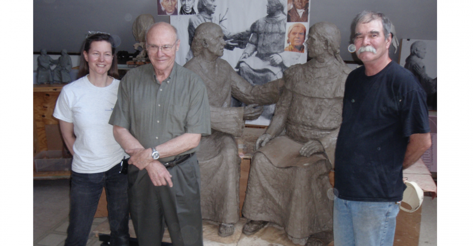 May 6, 2010: Lloyd Lillie (center) with his assistants Vicky Guerina and Jim Lochiatto in his studio in Newton, Massachusetts, with the completed clay models for the sculptures of Miguel Hidalgo and José Maria Morelos.
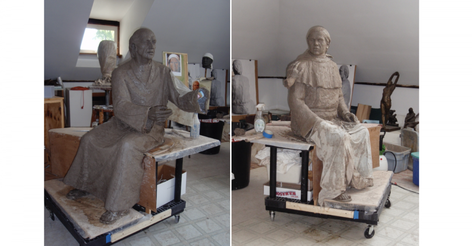 Detail of the clay models of the sculptures of Miguel Hidalgo and José Mariá Morelos
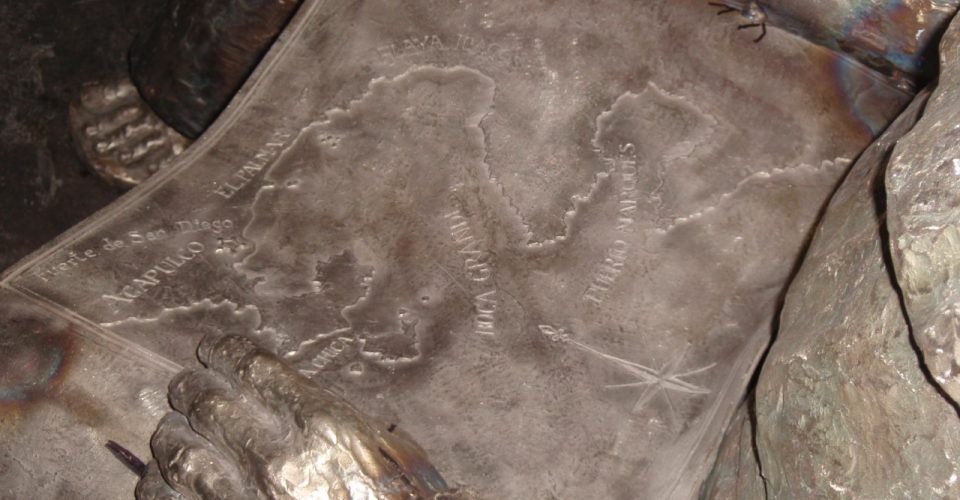 Cast in bronze in the lap of the José Maria Morelos sculpture by Lloyd Lillie and Vicky Guerina is a map showing the location of the Fort of Acapulco, modeled by Jim Montogomery. This map is based on the original survey that Alexander von Humboldt drew in 1811.
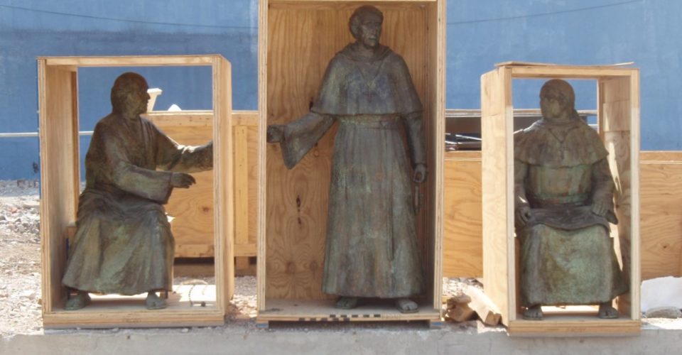 The bronze sculptures of Hidalgo, Urdaneta, and Morelos were cast at New England Sculpture Service in Massachusetts. They are shown here in their packing cases on April 16, 2011, soon after their arrival in Chilpancingo
 Construction of the arch at the entrance to the Bicentennial Park began in January 2011 and took about three months to buildBy mid-April 2011, the arch was ready for the installation of the meridian line, the North-South line that runs through its center
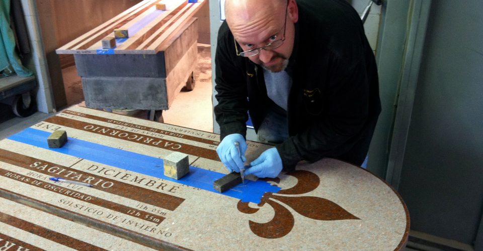 March 12, 2011: Gary Hahn making some finishing touches to the Chilpancingo Arch meridian, which he has just engraved
 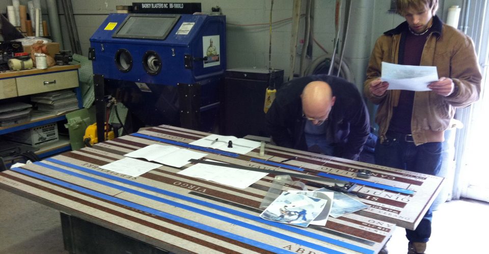 Chilpancingo Arch meridian with Gary Hahn and his son Justin
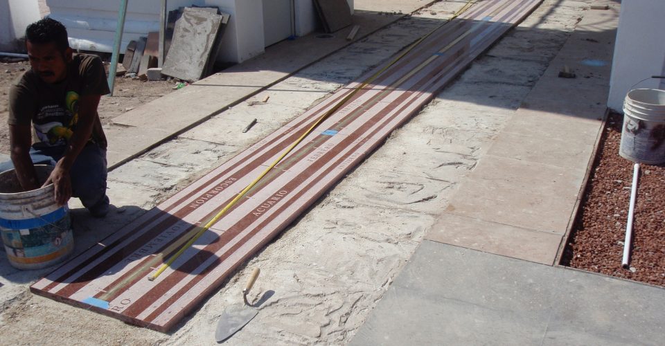 By April 16, 2011, the meridian installation was underway
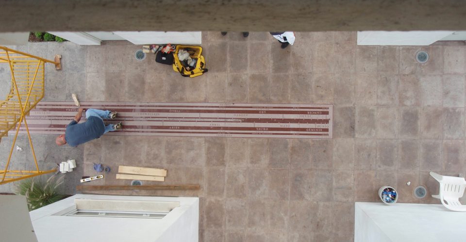 Gary working on the meridian
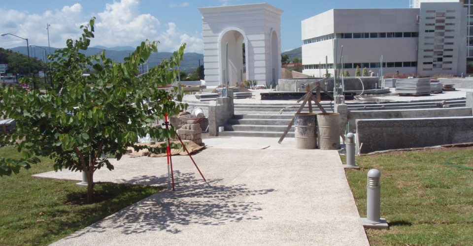 View of the Bicentennial Arch from the Northwest